Liquids/Liquid objects/Mercury
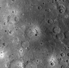
"A large part of Mercury could be covered in dried lava. The planet's northern plains appear smooth because lava may have poured over the surface, smoothing it out as it moved. Although scientists don't see volcanic activity on Mercury's surface now, many think it could be a good explanation for the way the planet looks today. The two crater rings in this image might have been smoothed by volcanic material, according to NASA."[1]
Intercrater plains
[edit | edit source]
"Mercury's oldest surface is its intercrater plains [1,3], which are present (but much less extensive) on the Moon. The intercrater plains are level to gently rolling terrain that occur between and around large craters. The plains predate the heavily cratered terrain, and have obliterated many of the early craters and basins of Mercury [1,4]; they probably formed by widespread volcanism early in mercurian history."[2]
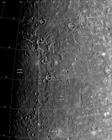
In the image on the right are abundant shallow elongate craters and crater chains are present on the plains. This image, taken during the first mission of Mariner 10, shows a large tract of inter-crater plains centered at 3° N, 20° W. The scarp running down the middle of the image, Santa Maria Rupes cuts through both the plains and large craters. The scene is 200 km across; north is the top.
Smooth plains are widespread flat areas that fill depressions of various sizes and bear a strong resemblance to the lunar maria. Unlike lunar maria, the smooth plains of Mercury have the same albedo as the older inter-crater plains. Despite a lack of unequivocally volcanic characteristics, the localisation and rounded, lobate shape of these plains strongly support volcanic origins.[3] All the smooth plains of Mercury formed significantly later than the Caloris basin, as evidenced by appreciably smaller crater densities than on the Caloris ejecta blanket.[3]
Impact basins and craters
[edit | edit source]
Mercury was heavily bombarded by comets and asteroids during an episode called the Late Heavy Bombardment that ended 3.8 billion years ago.[4] During this time Mercury was volcanically active; basins were filled by magma, producing smooth plains similar to the maria found on the Moon.[5][6] An unusual crater with radiating troughs has been discovered that scientists called "the spider".[7] It was later named Apollodorus.[8]
Caloris basins
[edit | edit source]

The largest known crater is Caloris Basin, with a diameter of 1,550 km.[9] The impact that created the Caloris Basin was so powerful that it caused lava eruptions and left a concentric ring over 2 km tall surrounding the impact crater. The floor of the Caloris Basin is filled by a geologically distinct flat plain, broken up by ridges and fractures in a roughly polygonal pattern. It is not clear whether they are volcanic lava flows induced by the impact or a large sheet of impact melt.[3]

At the antipode of the Caloris Basin is a large region of unusual, hilly terrain known as the "Weird Terrain". One hypothesis for its origin is that shock waves generated during the Caloris impact traveled around Mercury, converging at the basin's antipode (180 degrees away). The resulting high stresses fractured the surface.[10]
Or, this terrain may have formed as a result of the convergence of ejecta at this basin's antipode.[11]
"Scientists think that a huge asteroid slammed into Mercury about 4 billion years ago, creating a giant crater about 960 miles (1,545 km) across. Called the Caloris Basin, the crater could fit the whole state of Texas inside it. Researchers have calculated that the asteroid that created the basin had to have been about 60 miles (100 km) wide."[12]
"Analysis of radio tracking data have enabled maps of the gravity field of Mercury to be derived. In this image [second down on the right], overlain on a mosaic obtained by MESSENGER's Mercury Dual Imaging System and illuminated with a shape model determined from stereo-photoclinometry, Mercury's gravity anomalies are depicted in colors. Red tones indicate mass concentrations, centered on the Caloris basin (center) and the Sobkou region (right limb). Such large-scale gravitational anomalies are signatures of subsurface structure and evolution. The north pole is near the top of the sunlit area in this view."[13]
"Color differences on Mercury are subtle, but they reveal important information about the nature of the planet's surface material. A number of bright spots with a bluish tinge are visible in this image. These are relatively recent impact craters. Some of the bright craters have bright streaks (called "rays" by planetary scientists) emanating from them. Bright features such as these are caused by the presence of freshly crushed rock material that was excavated and deposited during the highly energetic collision of a meteoroid with Mercury to form an impact crater. The large circular light-colored area in the upper right of the image [on the left] is the interior of the Caloris basin. Mariner 10 viewed only the eastern (right) portion of this enormous impact basin, under lighting conditions that emphasized shadows and elevation differences rather than brightness and color differences. MESSENGER has revealed that Caloris is filled with smooth plains that are brighter than the surrounding terrain, hinting at a compositional contrast between these geologic units. The interior of Caloris also harbors several unusual dark-rimmed craters, which are visible in this image. The MESSENGER science team is working with the 11-color images in order to gain a better understanding of what minerals are present in these rocks of Mercury's crust."[14]
Overall, 46 impact basins have been identified.[15] A notable basin is the 400 km wide, multi-ring Tolstoj Basin that has an ejecta blanket extending up to 500 km from its rim and a floor that has been filled by smooth plains materials. Beethoven Basin has a similar-sized ejecta blanket and a 625 km diameter rim.[3] Like the Moon, the surface of Mercury has likely incurred the effects of space weathering processes, including solar wind and micrometeorite impacts.[16]
Astrogeology
[edit | edit source]


"The crater in the lower right-hand corner of this image [on the right] has a patch of very dark material located near its center. The region of this image has been seen only with the Sun high overhead in the sky. Such lighting conditions are good for recognizing color differences of rocks but not well suited for ascertaining the topography of surface features from shadows. The shape of the surface in this area is difficult to resolve given the lighting angle, but the dark patch is not in shadow. Dark surfaces have also been seen on other regions of Mercury, including this dark halo imaged during the second Mercury flyby (PIA11357) and near such named craters as Nawahi, Atget, and Basho seen during MESSENGER's first Mercury encounter. The example here is particularly striking, however, and from this NAC image the material may appear even darker than in other example areas. The dark color is likely due to rocks that have a different mineralogical composition from that of the surrounding surface. Understanding why these patches of dark rocks are found on Mercury's surface is a question of interest to the MESSENGER Science Team. The right edge of the image here aligns with this previously released NAC image (see PIA11763), where other dark surface material, as well as patches of light-colored rocks, can be seen."[17]
The second lower image on the right from the top shows "a double-ring impact basin, with another large impact crater on its south-south-western side. Double-ring basins are formed naturally when a large meteoroid strikes the surface of a rocky planet. Smaller, more recent impacts also formed comparatively fresh craters across the entire surface visible in this image. The floor within the inner or peak ring appears to be smoother than the floor between the peak ring and the outer rim, possibly the result of lava flows that partially flooded the basin some time after impact."[18]
The lowest image from the top on the right is a closeup of the weird terrain of Mercury.
"Weird terrain best describes this hilly, lineated region of Mercury. Scientists note that this area is at the antipodal point to the large Caloris basin. The shock wave produced by the Caloris impact may have been reflected and focused to the antipodal point, thus jumbling the crust and breaking it into a series of complex blocks. The area covered is about 800 km (497 mi) on a side."[19]
Volcanism
[edit | edit source]
There is evidence for pyroclastic flows on Mercury from low-profile shield volcanoes.[20][21][22] 51 pyroclastic deposits have been identified,[23] where 90% of them are found within impact craters.[23] A study of the degradation state of the impact craters that host pyroclastic deposits suggests that pyroclastic activity occurred on Mercury over a prolonged interval.[23]
A "rimless depression" inside the southwest rim of the Caloris Basin consists of at least nine overlapping volcanic vents, each individually up to 8 km in diameter. It is thus a "compound volcano".[24] The vent floors are at least 1 km below their brinks and they bear a closer resemblance to volcanic craters sculpted by explosive eruptions or modified by collapse into void spaces created by magma withdrawal back down into a conduit.[24] Scientists could not quantify the age of the volcanic complex system but reported that it could be of the order of a billion years.[24]
Reds
[edit | edit source]
"A higher-reflectance, relatively red material occurs as a distinct class of smooth plains that were likely emplaced volcanically; a lower-reflectance material with a lesser spectral slope may represent a distinct crustal component enriched in opaque minerals, possibly more common at depth."[25]
"The distinctively red smooth plains (HRP) appear to be large-scale volcanic deposits stratigraphically equivalent to the lunar maria (20), and their spectral properties (steeper spectral slope) are consistent with magma depleted in opaque materials. The large areal extent (>106 km2) of the Caloris HRP is inconsistent with the hypothesis that volcanism was probably shallow and local (10); rather, such volcanism was likely a product of extensive partial melting of the upper mantle."[25]
"Despite the dearth of ferrous iron in silicates, Mercury's surface nonetheless darkens and reddens with time like that of the Moon. This darkening and reddening has been interpreted to be the result of production of nanophase iron (e.g., Pieters et al., 2000; Hapke, 2001), which could be derived from an opaque phase in the crustal material or from delivery by micrometeorite impacts (Noble and Pieters, 2003). On the Moon, deposits that are brighter and redder than the average Moon spectrum appear to be lower in iron (e.g., highland material); deposits that are darker and redder than average are higher in iron (e.g., low-Ti mare material) (Lucey et al., 1995)."[26]
Craters
[edit | edit source]


Mercury's surface is heavily cratered and similar in appearance to Earth's Moon. For example, an unusual crater with radiating troughs has been discovered which scientists called "the spider."[27] Craters on Mercury range in diameter from small bowl-shaped cavities to multi-ringed impact basins hundreds of kilometers across. They appear in all states of degradation, from relatively fresh rayed craters to highly degraded crater remnants. Mercurian craters differ subtly from lunar craters in that the area blanketed by their ejecta is much smaller, a consequence of Mercury's stronger surface gravity.[3]
Overall, about 15 impact basins have been identified on the imaged part of Mercury. A notable basin is the 400 km wide, multi-ring Tolstoj Basin which has an ejecta blanket extending up to 500 km from its rim and a floor that has been filled by smooth plains materials. Beethoven Basin has a similar-sized ejecta blanket and a 625 km diameter rim.[3] Like the Moon, the surface of Mercury has likely incurred the effects of space weathering processes, including Solar wind and micrometeorite impacts.[28]
On November 29, 2012, NASA confirmed that images from the space probe Mercury Messenger had detected that craters at the north pole contained water ice.[29] Sean C. Solomon was quoted in the New York Times as estimating the volume of the ice as large enough to "encase Washington, D.C., in a frozen block two and a half miles deep."
A small crater named Hun Kal provides the reference point for measuring longitude. The center of Hun Kal is 20° west longitude.[30]
Mariner 10 provided the first close-up images of Mercury's surface, which immediately showed its heavily cratered nature.
"This spectacular view of the crater Degas [lower image on the right] was obtained as a high-resolution targeted observation (90 m/pixel). Impact melt coats its floor, and as the melt cooled and shrank, it formed the cracks observed across the crater. For context, Mariner 10’s view of Degas is shown at left. Degas is 52 km in diameter and is centered at 37.1° N, 232.8° E."[31]
The Scarlatti crater on Mercury has its center located at 40.71°N latitude, 101.09°W longitude.
Scarlatti crater is a pit crater.
"Pit craters are rimless steep-sided depressions that are inferred to have formed by non-impact processes."[32]
Pit "craters on Mercury formed through collapse into an underlying drained magma chamber. Pit-floor craters thus provide evidence for near-surface magmatic activity on Mercury and extend the range of evidence for magmatism beyond such surface expressions as smooth plains and pyroclastic deposits."[32]
Astrography
[edit | edit source]
The geography of the surface of Mercury (or Hermes) could be called Hermography or maybe Hermeography.
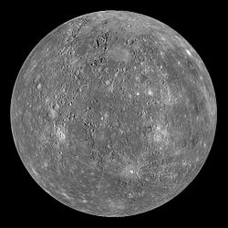
The image on the right is part of the first-ever complete map of Mercury's surface.
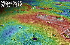
The image on the left is a topographic map of part of Mercury's surface.
"Measurements from MESSENGER's MLA instrument during the spacecraft's greater than four-year orbital mission have mapped the topography of Mercury's northern hemisphere in great detail. The view shown here is an interpolated shaded relief map of these data. The lowest regions are shown in purple, and the highest regions are shown in red. The difference in elevation between the lowest and highest regions shown here is roughly 10 kilometers! Among the prominent features visible here are the smooth northern volcanic plains and the enigmatic northern rise. The low-lying craters near the north pole host radar-bright materials, thought to be water ice. Linear artifacts can be seen in some areas of this map. These are due to individual MLA tracks that need minor adjustments in order to fit the rest of the data. Crossover analysis and better knowledge of the spacecraft position can be used to adjust these tracks and improve the map."[33]
Hypotheses
[edit | edit source]- Most of the surface of Mercury is cooled lava.
- Most of the surface of Mercury is the result of volcanism.
- Magma occurs over all Mercury.
See also
[edit | edit source]References
[edit | edit source]- ↑ Miriam Kramer (March 28, 2013). Green Meteorite May Be from Mercury, a First. SPACE.com. http://www.space.com/20426-mercury-meteorite-discovery-messenger.html. Retrieved 2013-03-31.
- ↑ Pauk D. Spudis (2001). The Geological History of Mercury, In: Workshop on Mercury: Space Environment, Surface, and Interior. Chicago. p. 100. Bibcode: 2001mses.conf..100S. https://www.lpi.usra.edu/meetings/mercury01/pdf/8029.pdf.
- ↑ 3.0 3.1 3.2 3.3 3.4 3.5 Spudis, Paul D. (2001). "The Geological History of Mercury". Workshop on Mercury: Space Environment, Surface, and Interior, Chicago (1097): 100.
- ↑ Strom, Robert G. (1979). "Mercury: a post-Mariner assessment". Space Science Reviews 24 (1): 3–70. doi:10.1007/BF00221842.
- ↑ Geology of the solar system. IMAP 2596. U.S. Geological Survey. 1997. doi:10.3133/i2596.
- ↑ Head, James W.; Solomon, Sean C. (1981). "Tectonic Evolution of the Terrestrial Planets". Science 213 (4503): 62–76. doi:10.1126/science.213.4503.62. PMID 17741171. http://www.planetary.brown.edu/pdfs/323.pdf.
- ↑ "Scientists see Mercury in a new light". Science Daily. February 28, 2008. Retrieved April 7, 2008.
- ↑ "The Giant Spider of Mercury". The Planetary Society. Retrieved June 9, 2017.
- ↑ David Shiga (January 30, 2008). Bizarre spider scar found on Mercury's surface. NewScientist.com news service. http://space.newscientist.com/article/dn13257-bizarre-spider-scar-found-on-mercurys-surface.html.
- ↑ Schultz, Peter H.; Gault, Donald E. (1975). "Seismic effects from major basin formations on the moon and Mercury". Earth, Moon, and Planets 12 (2): 159–175. doi:10.1007/BF00577875.
- ↑ Wieczorek, Mark A.; Zuber, Maria T. (2001). "A Serenitatis origin for the Imbrian grooves and South Pole-Aitken thorium anomaly". Journal of Geophysical Research 106 (E11): 27853–27864. doi:10.1029/2000JE001384. http://www.agu.org/pubs/crossref/2001/2000JE001384.shtml. Retrieved May 12, 2008.
- ↑ Miriam Kramer (28 January 2015). 10 Strange Facts About Mercury (A Photo Tour). Space.com. http://www.space.com/27013-strange-mercury-facts-photos.html. Retrieved 2015-05-14.
- ↑ Sue Lavoie (15 April 2015). PIA19285: Gravity Anomalies. Pasadena, California USA: NASA/JPL. http://photojournal.jpl.nasa.gov/catalog/PIA19285. Retrieved 2015-05-15.
- ↑ JHU/APL (January 30, 2008). Mercury Shows Its True Colors. Baltimore, Maryland USA: JHU/APL. http://messenger.jhuapl.edu/gallery/sciencePhotos/image.php?page=1&gallery_id=2&image_id=143. Retrieved 2013-04-01.
- ↑ Fassett, Caleb I.; Head, James W.; Baker, David M. H.; Zuber, Maria T.; Smith, David E.; Neumann, Gregory A.; Solomon, Sean C.; Klimczak, Christian et al. (October 2012). "Large impact basins on Mercury: Global distribution, characteristics, and modification history from MESSENGER orbital data". Journal of Geophysical Research 117: 15 pp.. doi:10.1029/2012JE004154. E00L08.
- ↑ Denevi, Brett W.; Robinson, Mark S. (2008). "Albedo of Immature Mercurian Crustal Materials: Evidence for the Presence of Ferrous Iron". Lunar and Planetary Science 39 (1391): 1750.
- ↑ Sue Lavoie (6 October 2008). PIA11389: A Patch of Black. Pasadena, California USA: NASA/JPL. http://photojournal.jpl.nasa.gov/catalog/PIA11389. Retrieved 2015-02-03.
- ↑ Christina Dorr; Julie Taylor (29 September 2009). Seeing Double?. Baltimore, Maryland USA: Johns Hopkins University Applied Physics Laboratory. http://messenger.jhuapl.edu/gallery/sciencePhotos/image.php?gallery_id=2&image_id=338. Retrieved 2015-02-03.
- ↑ Colleen Schroeder (10 May 2005). Hills of Mercury. Pasadena, California USA: NASA/JPL. http://pds.jpl.nasa.gov/planets/captions/mercury/mercter.htm. Retrieved 2015-02-03.
- ↑ Kerber, Laura; Head, James W.; Solomon, Sean C.; Murchie, Scott L.; Blewett, David T. (August 15, 2009). "Explosive volcanic eruptions on Mercury: Eruption conditions, magma volatile content, and implications for interior volatile abundances". Earth and Planetary Science Letters 285 (3–4): 263–271. doi:10.1016/j.epsl.2009.04.037.
- ↑ Head, James W.; Chapman, Clark R.; Strom, Robert G.; Fassett, Caleb I.; Denevi, Brett W. (September 30, 2011). "Flood Volcanism in the Northern High Latitudes of Mercury Revealed by MESSENGER". Science 333 (6051): 1853–1856. doi:10.1126/science.1211997. PMID 21960625. https://authors.library.caltech.edu/72395/2/Head.SOM.pdf.
- ↑ Thomas, Rebecca J.; Rothery, David A.; Conway, Susan J.; Anand, Mahesh (September 16, 2014). "Long-lived explosive volcanism on Mercury". Geophysical Research Letters 41 (17): 6084–6092. doi:10.1002/2014GL061224. http://oro.open.ac.uk/40782/.
- ↑ 23.0 23.1 23.2 Groudge, Timothy A.; Head, James W. (March 2014). "Global inventory and characterization of pyroclastic deposits on Mercury: New insights into pyroclastic activity from MESSENGER orbital data". Journal of Geophysical Research 119 (3): 635–658. doi:10.1002/2013JE004480. http://www.planetary.brown.edu/pdfs/4334.pdf.
- ↑ 24.0 24.1 24.2 Rothery, David A.; Thomas, Rebeca J.; Kerber, Laura (January 1, 2014). "Prolonged eruptive history of a compound volcano on Mercury: Volcanic and tectonic implications". Earth and Planetary Science Letters 385: 59–67. doi:10.1016/j.epsl.2013.10.023. http://oro.open.ac.uk/38842/1/Rothery2.pdf.
- ↑ 25.0 25.1 Mark S. Robinson; Scott L. Murchie; David T. Blewett; Deborah L. Domingue; S. Edward Hawkins III; James W. Head; Gregory M. Holsclaw; William E. McClintock et al. (July 4, 2008). "Reflectance and Color Variations on Mercury: Regolith Processes and Compositional Heterogeneity". Science 321 (5885): 66-9. doi:10.1126/science.1160080. http://www.sciencemag.org/content/321/5885/66.short. Retrieved 2013-07-28.
- ↑ Laura Kerber; James W. Head; Sean C. Solomon; Scott L. Murchie; David T. Blewett; Lionel Wilson (2009). [http://www.sciencedirect.com/science/article/pii/S0012821X09002611 "Explosive volcanic eruptions on Mercury: Eruption conditions, magma volatile content, and implications for interior volatile abundances"]. Earth and Planetary Science Letters 285: 263-71. doi:10.1016/j.epsl.2009.04.037. http://www.sciencedirect.com/science/article/pii/S0012821X09002611. Retrieved 2013-07-28.
- ↑ Staff (February 28, 2008). Scientists see Mercury in a new light. Science Daily. http://www.sciencedaily.com/releases/2008/02/080201093149.htm. Retrieved 2008-04-07.
- ↑ Denevi, B. W.; Robinson; Robinson, M. S. (2008). "Albedo of Immature Mercurian Crustal Materials: Evidence for the Presence of Ferrous Iron". Lunar and Planetary Science 39: 1750.
- ↑ Kenneth Chang (2012-11-29). On Closest Planet to the Sun, NASA Finds Lots of Ice. New York Times. p. A3. https://www.nytimes.com/2012/11/30/science/space/mercury-home-to-ice-messenger-spacecraft-findings-suggest.html.
- ↑ USGS Astrogeology: Rotation and pole position for the Sun and planets (IAU WGCCRE). http://astrogeology.usgs.gov/Projects/WGCCRE/constants/iau2000_table1.html. Retrieved 22 October 2009.
- ↑ NASA/Johns Hopkins University Applied Physics Laboratory/Carnegie Institution of Washington (16 June 2011). Targeted Color Imaging: Degas Crater. Baltimore, Maryland USA: Johns Hopkins University Applied Physics Laboratory. http://messenger.jhuapl.edu/gallery/sciencePhotos/image.php?page=1&gallery_id=2&image_id=537. Retrieved 2015-02-03.
- ↑ 32.0 32.1 Jeffrey J. Gillis-Davis; David T. Blewett; Robert W. Gaskell; Brett W. Denevi; Mark S. Robinson; Robert G. Strom; Sean C. Solomon; Ann L. Sprague (August 2009). "Pit-floor craters on Mercury: Evidence of near-surface igneous activity". Earth and Planetary Science Letters 285 (3-4): 243-50. doi:10.1016/j.epsl.2009.05.023. http://www.sciencedirect.com/science/article/pii/S0012821X09003100. Retrieved 2015-05-17.
- ↑ Karen Boggs (16 April 2015). PIA19420: The Ups and Downs of Mercury's Topography. Pasadena, California USA: NASA/JPL. http://photojournal.jpl.nasa.gov/catalog/PIA19420. Retrieved 2015-05-15.


