Low-Cost Precision Farming
Appearance
(Redirected from Precision agriculture)


Low-Cost Precision Farming applies the concept of Low-Cost Technology to farming and agriculture.
Components of Low-Cost Precision Agriculture
[edit | edit source]


- Understand the general principles of the application of Low-Cost Technology and Low-Cost approaches in general
- connect the Low-Cost principles to the impact side of the Risk definition. Low-Cost, more people can used, higher impact on risk mitigation. Compare that benefit with the downside of the approach, that the low-cost approach might not have such a high impact on risk mitigation.
- explore the optical options of input for creating the mapsof low cost precision farming!
- explore the methods of processing the images to create a Spatial Decision Support Layer from the image. Start with the Normalized Difference Vegetation Index NDVI with NDVI-Tutorial.
Learning Steps
[edit | edit source]- (Spectral Analysis) Learn about the concepts behind spectral analysis and apply the lessons learnt to remote sensing images (see Youtube-Video about Remote Sensing and Spectral Analysis[2]).
- (Precision Agriculture) Learn about Precision Agriculture in general with high technical equiment
- (Long-term Health and short-term Economic Benefit) Explore options to combine low-cost technology with (Mobile Devives and Open Source) with economic benefits for farm workers manual that
- reduce the needed amount of agrochemicalslabor,
- create a short-term economic benefit by reduced quantity of agrochemicals,
- create less exposure to flora and fauna to agrochemicals
- establish long-term health benefit by establishment of risk mitigation strategies for the farm workers.
- Compare the main purpose of risk mitigation for humans and environment as a long-term benefit with the short-term economic driver for change. Which driver will have a better impact on risk mitigation for farm workers and how can you measure the impact in a comparative study.
- Explore errors in scientific reasoning according to multifactorial diseases.
- (Low-Cost Technology) Explore the Solar water desinfection approach and identify the general principles of Low-Cost technology to transfer that concept to Precision Farming. Assume a group a farmers share one mobile device and internet connectivity can be assured in some very few places and if and only if the travel 3h. Furthermore assume there is a data exchange in place between groups of farmers that share capacity building resources and open data via Bluetooth. Learn about general principles of Precision Agriculture and transfer that to Low-Cost Technology.
- (Precision Global Health) Compare the concepts of Precision Global Health and Precision Agriculture. What do these concepts have in comment and what are the differences? Precision Agriculture aims to reduce the application of agrochemical in a dose tailored to the geolocation, to keep the harvest yield and minimize the amount of used agrochemicals. Environmental health and public health is linked in many ways. Identify those links and derive a way forward for optimized support for decision making! Find scientific evidence for you approach!
Learning Tasks
[edit | edit source]- (Water) Water is resource for plants. Explain how the availability of water and moisture of the soil can be detected with remote sensing.
- (Climate Change) Climate change impact on farming and Heat stress of plants. Spectrum of light emission in the small visible electro magnetic range of the spectrum changes e.g. from a lighter green in spring into darker greener in summer and into brown color in autumn. These are the visible impacts everyone knows. Search and explain other areas of frequencies in the electromagnetic spectrum and explain what spectral analysis can tell us about the status of the plant. In which area of the spectrum would you expect to detect the heat stress of plants. Compare different plants and expose them to the same heat stress. How can you detect, which plant is more resillient to heat stress?
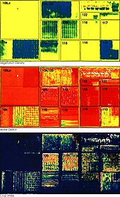
- (NDVI) Explain the concept of a Normalized Difference Vegetation Index (NDVI) and learn to calculate the NDVI with Open Source Software with a learning resource in Wikiversity.
About the Learning Resource
[edit | edit source]This learning resource is based on the Open Community Approach. So learner should be able to work with the topic with open data and open source software, so that they can share their results, findings and products in the community with other learners. Furthermore local and regional requirements and constraints need an adaptation of the learning resource to local and regional constraints. So the content of the learning resource is stored in Wikiversity as Open Educational Resource (OER).
See also
[edit | edit source]- Climate Change
- Food Security
- Electromagnetic radiation
- Water
- Wikipedia:Precision agriculture
- Wikipedia:Spectroscopy - Spectral analysis of light reflected or emitted by an object can be used to detect properties of the matter or object itself. This generic principle can be applied to remote sensing image of plants in conjunctions with soil.
- Space Technology and Drones in Agriculture for detecting of crop health and derive management decisions for agriculture
- SOlar water DISinfection (SODIS) as a low-cost approach for risk mitigation
- Calculate a Regional NDVI
- International Society for Photogrammetry and Remote Sensing
References
[edit | edit source]- ↑ "Precision Farming : Image of the Day". earthobservatory.nasa.gov. Retrieved 2009-10-12.
- ↑ Neon Science (2015) Mapping the Invisible: Introduction to Spectral Remote Sensing, Youtube-Video URL: https://www.youtube.com/watch?time_continue=36&v=3iaFzafWJQE - (accessed 2019/07/20)
