
Open Educational Resources/geo-located OER
Even if learning resources are presented at Wikiversity as a digital media, learning processes itself taking place with interaction with your
- social,
- cultural,
- educational,
- scientific,
- ...
environment. Taking these requirements and constraints into account leads to geo-located Open Educational Resources that are adapted to the location where they are used.
Attach Learning Resouces to Geolocations
[edit | edit source]OER attached to Geolocations: Imagine your could attach digital Open Educational Resource to a real geolocation. The geolocation is e.g. a small river and use "Augmented Reality Tutorial" for visualization of OER:
- Attach a video that shows the place from a bird view.
- Provide a online questionnaire about the biological environmental observations at the river.
- Attach an image, how the river will look in winter.
- Visualize the work of mircro-bacteria doing work in the river.
- Show historic images of the river from the year 1912 and let the visitors analyse the human alteration in the river bed.
Wiki Products and Geolocated OER
[edit | edit source]If we analyse producte of the WikiMedia foundation for geolocation attributes, the following can be identified:
- (Language and Geolocation) language of a learning resource in Wikiversity can be to make a rough af´sssignment to a geographical area in which the language is spoken.
- Latitude/Longitude can make a reference to a Point of Interest (POI) or a building (see coordinates Vienna International Centre upper right corner of article[1])
- (Geonames) Denomination of a country, city, address, ...
- (Geographical Area) define an area on the globe by a sequence of several geolocations (points). Let be a point as a single longitude/latitude pair . A "triangle" is a geographical area consisting of three points :.


Learning Tasks
[edit | edit source]
- (Geo-located AR) Jerome Etienne create AR.js based on the libraries Aframe and three.js library. Nicolo Carpignoli worked on Geolocated Augmented Reality and merge the concept with a marker based augmented reality (see 3D Modelling). In 2020 the Open Source Augemented Reality package AR.js contains 3 different AR approaches:
- Marker based (initiated by Jerome Etienne)
- Geo-location based (developed by Nicolo Carpignoli)
- Image Tracking based (AR.js Community)
- In this context we can geolocated Open Educational Resources
- with QR-Codes at special places that encode small infomation as content directly or a reference/URL to OER that could be digital media of any kind that supports learner at the geolocation she/he is currently at.
- Augemented Reality visualizing additional content as specific geolocations (see also animated examples of AR.js on project web portal)
- (Photogrammetry) Explain how Photogrammetry or historical site (e.g. Forum Romanum in Rome) can be used together with 3D Modelling on Markers
- (Wikiversity:Edit-a-thon) visit a specific location with a group of educators, teachers and identify topics for an edit-a-thon for this specific geo-location. Run the edit-a-thon and create Open Educational Resources in Wikiversity with the educators. Perform a follow-up meeting for the edit-a-thon with the edit-a-thon participants and test the geo-location OER with the group of learners, students and collect their feedback for improving the learning resource.
History of Approach
[edit | edit source]Community of Practice in the Action Team 6 Follow Up initiative and international approaches of Risk Mitigation strategies analysed the peaceful use of space technology (see UN-COPUOS[2]). Having risk mitigation strategies for communities in mind, capacity building and learning is one of the key elements, that help organisations to support the communities exposed to risks. United Nations support that in many areas (Climate Change, Humantarian Aid, Disaster Management, Global Health). This learning resource is based on results of the community of practice in AT6FUI/EFG-SGH by piloting protoyping ideas (see AT6FUI/Expert Focus Group for Space and Global Health. But the learning resource is designed in way that generic princples like "attaching digital information to geolocation" are used as topic of the learning resource, because the generic geospatial principles can be used and transfered to other educational settings or use-cases for capacity building as well.
Geolocation OER for Risk Management
[edit | edit source]To learn about strategies to mitigate the risk includes improvement of risk literacy. The access to the open educational resources for everyone is necessary to reach people that are exposed to risks. Wikiversity provides OER and it at the same time a collaborative environment for teachers and learner. At the interface of organisational capacity building the concept of an One fits all approache does not work in general and especially not for educational resources. Language, social and cultural determinants are relevant how learner perceive risks. This implies that learning resource had to be tailored to this determinants. Wikiversity allows the alteration, remix, adaptation to local and regional requirements and constraints. So geospatial aspects are relevant for educational resources as well. Wiki products allow the attachment of articles to specific geolocation (see United Nations Building VIC in Vienna - upper right corner). The georeferencing can be used by service like http://www.geonames.org/[3]. Based on such a service the latitude and longitude of the learber can be used find nearby learning resources in Wikiversity. Even augemented reality tools like Mixare can used along with the webservices to place geolocated learning resources digital information that make reference to geolocation where the user is.
Design Example of geolocated OER
[edit | edit source]Assume a group of learner will visit the Niagara Falls. Teacher could enrich the geolocation with additional media:
- video from a helicopter,
- looking into the past: the first snapshots of the location from beginning of photography,
- Open Literature, open poems, that refer to the geolocation,
- mircoscope views about the aquativ life,
- how will the Niagara Falls evolve in next 100000 year as projections in the future
- how does the place look in Winter, Spring, Summer, Autumn, ... temporal aspect
- ...
The geolocated OER involve learning tasks that trigger the interaction of the learner with the environment.
Images Maps - A way of visual exploration of Learning Resources
[edit | edit source]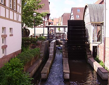
An image is a standard way for illustration of text documents. A image map attached links to certain areas on the image. Learners can click on the image and explore details and further information. A geolocated Learning Resoure can use this concept to allow exploration of a geolocation without being at this geographic location. This is helpful as a preparation for a physical visit of that place (see Real World Lab). The image on the right is a small example of on image map.
Commercial Use of tailored information for geolocation
[edit | edit source]Geolocted OER applied a basic geospatial principle to OER, which is widely used in the commercial sector:
- Games like P0K0M0N G0 allows guiding users to commercially interesting location,
- advertisments from mobile phone users can be placed the ads tailored to geo-location of mobile phone user (see Commercial Data Harvesting),
- travel guides can provide digital information for the geolocation/city/leisure park on mobile devices,
- ...
All applications show the same generic geo-spatial principle:
- Provide information tailored to the geo-location of the user
Extend Perspective of Teachers on the Design of Learning Resources
[edit | edit source]The use of digital devices has changed and in development countries the era of desktop computers skipped and the first computer will be mobile device. Have the geospatial principle in mind the major shift can be summarized as:
- Instead of sitting in front of Desktop Computer with internet connection watching multimedia content about a geolocation, the mobile device learners at the geolocation interact with the physical environment around with the opportunity to enrich the experience with digital support and context information about the location they are currently living and working in.
The awareness of teachers about this basic geo-spatial principle changes the design of learning resources with a combination of learning resources used in the classroom and outside the classroom where the learners can get real experiences with the subject considered in the learning process.
(Teachers Training) Learning resources for teachers training in Wikiversity start with
- general awarness about the application of geospatial principles and
- then the learning task in teachers training is the application of the principle their own expertise and their country or region they live in.
- finally a more advanced task is to decompose the developed learning resource in parts that are applicable for other geolocations and areas as well and into parts that just refer to the specific geolocation.
Importance of geolocated OER for Risk Management
[edit | edit source]If someone lives in the Antarctica research station then it doesn't make sense to inform the researcher about malaria risks. If you're going on holiday to the Kruger National Park, then risk mitigation information is helpful about the use of mosquito repellent, Mosquito nets or take malaria prophylaxis.
App Development for geospatial OER in Wikiversity
[edit | edit source]Mixare is a good starting point to explore the possibilities of such an approach. Also the software design analysis is helpful to learn about the import of geospatial "nearby"-databases with OpenSource technology.
Looking teachers without IT background a productive use of these approach has a requirement, that with assignment of a geolocation in a Wikipedia learning resource, this learning resource or any other wikipedia article should be available in the Augmented Wiki Browser. No additional workload should be necessary for teacher to import the "nearby"-learning resource of "nearby"-Wikipedia article.
From the software development side the Mixare-approach needs the refactoring of code or a reimplementation as multiplatform application as HTML5/JS/CSS app (suggestion might be moved to a meta area of Wiki products in general).
Crowd funding could support the development of a Open Source app that allows teachers
- to use geolocated learning resources,
- place learning resource as teachers to specific geolocation and
- have something an Open Source MediaWiki Browser structural equivalent to Mixare that allows teacher to create geolocated OER just by placement of latitude and longitude in the OER.
A major improvement of Mixare is necessary mainly for the reduction the workload for teachers and not from the usability for learners to retrieve Open Educational Resource that a relevant to their CURRENT geolocation. Technically an improvement of access to mobile phone sensors especially GPS location must be tested for current devices and operating systems (stability)
Think globally, act locally
[edit | edit source]The approach "Think globally, act locally"[4] can be applied to learning resources. Global approaches in a learning resouce lead to local or regional implementations/specialisation of OER that respects local cultural, social requirements and the local constraints to selected location as learning resource.
Sea also
[edit | edit source]- Real World Lab: application of geolocated OER tailored for the Real World Lab
- 3D Modelling as Open Educational Resources for a Digital Learning Environment or Capacity Building
- geo-located OER in the context of Space and Global Health
References
[edit | edit source]- ↑ Nielsen, F. A. (2016, April). Literature, Geolocation and Wikidata. In Wiki@ ICWSM.
- ↑ Hosenball, S. N. (1979). The United Nations Committee on the peaceful uses of outer space: Past accomplishments and future challenges. J. Space L., 7, 95.
- ↑ Speiser, S., & Harth, A. (2010, November). Towards linked data services. In Proceedings of the 2010 International Conference on Posters & Demonstrations Track-Volume 658 (pp. 157-160). CEUR-WS. org.
- ↑ Kefalas, A. G. (1998). Think globally, act locally. Thunderbird International Business Review, 40(6), 547-562.