
Geography/Background
Geography is the study of the physical world around us and the way humans have impacted it, through their nations, cities, and general way of life. Geography is an important study, and in many ways a science, of Earth as we know it. To become a good student of geography, one must study to the point that they are familiar with a world map or any regional map, and so they have a general idea of the location of countries, major cities within those countries, and major physical features, like mountains and important rivers.
Geography and geology are rather close and an advanced study of either subject could lead to extensive overlap between the two. One may be used as a supplement to the other, but geology is not a prerequisite to a decent understanding of geography.
Historically, one of the primary uses of geography has been in cartography. Compare these two maps of the world, one from ancient times and one that is modern:
-
 Ancient
 -
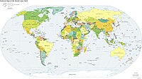 Modern
,_ff.68v-69_-_BL_Add_MS_15760.jpg)
.jpg)
As you can see by looking at the maps, the ancient map does not include the New World, as it was not known to the cartographer at the time; and large regions are drawn, to the modern eyes, in a form that is clearly an incorrect representation of the shape of Earth's landmasses. Exploration and, in recent years, satellites have made accurate mapmaking attainable.
Basics of geography
[edit | edit source]The basics of geography, which are taught to young children but remain essential in this course, are the following:
- There is an imaginary line, called the equator, that goes east-west around the world, halfway between the North and South Poles. Various other lines, called latitude lines, run parallel with the equator. These are assigned numbers, like 7th degree north (or 7th parallel), 8th degree north, etc.
- Another imaginary line (the Prime Meridian) runs north-south approximately through London, England, going from the North Geographical Pole all the way to the South Geographical Pole. Various other lines, called longitude lines, run parallel to this line. A compass does not point to the North Geographical Pole, but instead the North Magnetic Pole, which moves some distance from the geographical pole.
- There are generally considered to be five oceans: the Pacific, Atlantic, Indian, Arctic, and Southern Oceans.
- There are generally considered to be either six or seven continents: Africa, Antarctica, Australia, Europe/Asia, North America, and South America.
- There are only six continents if Asia and Europe are counted as one continent. A website called What are the Seven Continents goes into more detail, which is unnecessary here. In short, because there is not a true geographical separation between these two regions, but instead a cultural one, for geographical purposes it is reasonable to consider Europe and Asia one continent called "Eurasia."
- When referring to the broader region surrounding Australia, and particularly to the east, including the Pacific islands and the island of New Guinea, it is known as "Oceania."
- While the number of countries is difficult to calculate exactly due to various claims and territorial disputes, there are roughly 200 countries around the world. Almost all of these countries have a capital city, or multiple capital cities, where government is located.
Getting to like geography
[edit | edit source]If you don't enjoy geography, you will find it harder to learn material. Therefore, it is recommended that check out the photos page, which shows pictures of places from around the world, to get you interested in the importance of studying geography: learning more about the diversity of the planet.
Quiz 1
[edit | edit source]Complete Geography/Quiz 1.