Coastal aquifer analysis
Coastal aquifers constitute a system where the interface fresh water – salt water is in a fragile balance. An important quantity of world population is situated in the coasts, and it subsists due to the use of groundwater.
Example: Argentina
[edit | edit source]HYDROLOGICAL BEHAVIOR IN THE NORTHEASTERN COAST OF BUENOS AIRES PROVINCE, ARGENTINA
[edit | edit source]The only fresh water source available to the population in the Northeastern region of Buenos Aires province is stored in the coastal dunes. Human activity in coastal areas generally leads to changes in the location and/or extension in groundwater recharge and discharge areas.
STUDY AREA AND GENERAL CHARACTERISTICS
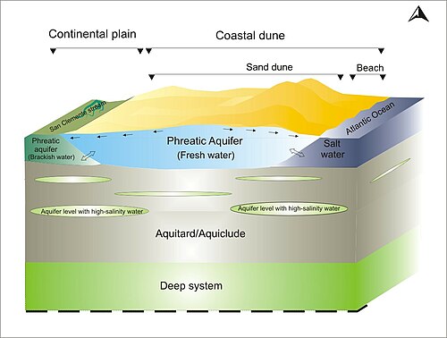
[edit | edit source]The study area is San Clemente del Tuyú, Partido de la Costa, Buenos Aires, Argentina (36º22' Lat S, 56º 44' Long W) (Figure 1). It is located in a fringe of coastal dunes where the fresh water lens is limited by two interfaces: brackish water - fresh water to the continent (west) and fresh water- salt water to the sea (east). Population growth and an increase in tourist activity associated with land-use change, produce modifications in the hydrological cycle (Kruse and Carretero, 2010)[1]

San Clemente del Tuyú is located in coastal dune and continental plain geomorphological environments. The coastal dune (Figure 2a) extends uninterruptedly from Punta Rasa to the south, the width varies between 2 and 4 km and it is divided into beach (Figure 2c) and dune (Figure 2b). The continental plain (Figure 2d) is located on the west of the coastal dune. The elevations are less than 5 m.a.s.l.(meter above sea level) and it is open to the sea in this region. (Consejo Federal de Inversiones, 1989)[2]

According to Thornthwaite´s climatic classification, the area is humid, mesothermal, with little or no water deficiency. (Consejo Federal de Inversiones, 1990)[3]. The average annual rainfall is 1000 mm of which the greater percentage occurs from October to March. The average annual temperature is 14.6 ° C, the average of relative humidity is 85% and the frequency of winds varies greatly, although the East direction is somewhat more predominant.
HYDROGEOLOGICAL CHARACTERIZATION
[edit | edit source]A shallow and a deep geohydrological system were recognized (Figure 3). It is possible to recognize two units in the shallow one: the fresh water lens, which is directly related to the current hydrological cycle, and the aquitard/aquiclude that contains some aquifer levels with high-salinity water. The fresh water lens thickness, in the central sector of the study area, varies between 4 and 10 m increasing from north to south and decreasing to the east towards the sea salt water interface and to the west, towards the continental brackish water. The deep system is lacking in data and therefore it is only possible to define it as a low permeability system that includes some sandy levels with high salinity and it is located from a depth of 92 m.

A monitoring network with 43 distributed wells was installed in the study area and monthly phreatic level surveys were carried out between November 2007 and July 2010. The results permit the construction of isophreatic, isodepth and isovariation maps.
The groundwater flux maps (Figure 4) show, generally, a high area in the phreatic morphology which coincides with the central and the highest part of the coastal dune that is the main groundwater recharge zone. The discharge takes place in two opposing directions, to the east towards the sea and to the west towards the continental plain. (Carretero, 2011)[4]

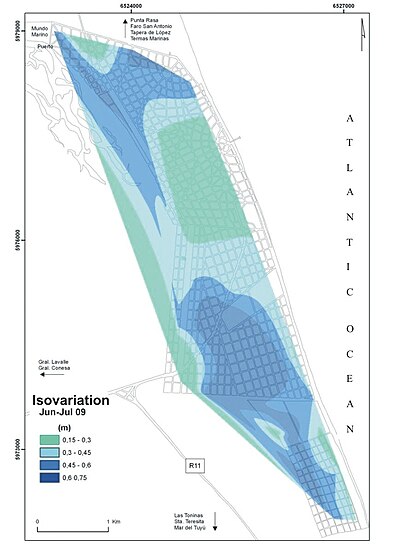
Based on isovariation maps (Figure 5) and fluctuation graphs (Figure 6) it was determined that the rise in the phreatic level occurs when accumulated precipitation between surveys (monthly) is greater than 60 mm.


Changes in land-use areas were analyzed (Figure 7) and different behaviors before the recharge were defined. In the area characterized by a sandy soil with scarce vegetation, phreatic level rise is three times greater than in the urbanized sector (Carretero et al, 2007, Carretero at al, 2008)[5][6].

WATER SUPPLY
[edit | edit source]In the study area, the permanent population is greater than 10,000 inhabitants (INDEC, 2001)[7]. In summer, the region is subjected to a high rate of tourism which multiplies the population by 5. The drinking water supply to the city is acquired from a pumping field located outside the urbanized area (Figure 8). The water exploitation is carried out through the use of Ranney type horizontal wells and Wellpoint systems situated in the coastal dune. The extraction depth varies between 4 m and 6 m (Carretero and Kruse, 2010)[8]. A general tendency towards deepening in time of the phreatic levels and a cone of depression were observed in the pumping field. It is necessary to increase the drinking water supply to cover the needs of a greater number of inhabitants. As increasing tourism levels exert greater pressure on water demand, these points must be considered when planning and implementing future summertime groundwater management plans. The management guidelines should include the selection of new exploitation areas, including a detailed water input and output quantification of the hydrological system. An areal exploitation at scarce depth is also recommended., and it is fundamental that the areas of use are declared reservation areas to conserve the recharge areas and to avoid all possible contamination of the groundwater.

REFERENCES
[edit | edit source]- ↑ Kruse E and Carretero S. 2010. Aguas subterráneas en el sector note del Partido de la Costa. En: Isla Federico. Manejo de Barreras Medanosas. Universidad Nacional de Mar del Plata, pp 27-38.
- ↑ Consejo Federal de Inversiones (1989). Evaluación del Recurso Hídrico Subterráneo de la Región Costera Atlántica de la Provincia de Buenos Aires Regiones I y II Punta Rasa-Punta Médanos. Provincia de Buenos Aires. Informe Final. Tomo 2. Geología y Geomorfología, p 192
- ↑ Consejo Federal de Inversiones (1990). Evaluación del Recurso Hídrico Subterráneo de la Región Costera Atlántica de la Provincia de Buenos Aires Región I Punta Rasa - Punta Médanos. Informe Final. Tomo IV. Caracterización climática y Balance Hidrológico, p 177.
- ↑ Carretero S. 2011. Comportamiento hidrológico de las dunas costeras en el sector nororiental de la provincia de Buenos Aires. Doctoral Thesis. Facultad de Ciencias Naturales y Museo. Universidad Nacional de La Plata. Argentina.
- ↑ Carretero, S., Kruse, E. and Forte Lay, J.A. 2007. Efectos de la urbanización en la recarga subterránea en San Clemente del Tuyú (Provincia de Buenos Aires). In: Proceedigs of the XXI Congreso Nacional del Agua., pp 1-12. Tucumán. Argentina.
- ↑ Carretero S., Kruse E. and Forte Lay J.A. 2008. Efectos de la urbanización sobre la recarga en médanos costeros. IX Congreso Latinoamericano de Hidrología Subterránea. Quito. Ecuador.pp 1-8
- ↑ INDEC, Instituto Nacional de Estadísticas y Censos (2001). Censo Nacional de Población, Hogares y Viviendas 2001.Argentina
- ↑ Carretero S. and Kruse E. 2010. Areal exploitation of groundwater in coastal dunes, Buenos Aires. Argentina. En B.S. Paliwal (editor). Global Groundwater Resources and Management. Selected Papers from The 33rd International Geological Congress, General Symposium: Hydrogeology, Oslo (Norway) Aug. 6-14, 2008. Sientific Publishers (India), Jodhpur, pp. 385-398.
