Category:Geology images
Jump to navigation
Jump to search
Subcategories
This category has the following 10 subcategories, out of 10 total.
G
- Geodetics images (3 files)
- Geomorphology images (11 files)
- Geoseismology images (6 files)
- Glaciology images (1 pg, 135 files)
H
- Hydromorphology images (13 files)
P
- Petrophysics images (empty)
R
S
- Structural geology images (4 files)
Media in category "Geology images"
The following 29 files are in this category, out of 29 total.
- 5654768824 63fa89670a m.jpg 240 × 161; 40 KB
- Bathymetry and selected features of the seas around Scotland.png 1,457 × 1,082; 1.81 MB
- Bathymetry of the NES LME and adjacent offshore waters.png 480 × 479; 309 KB
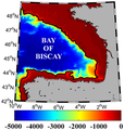
- Bay of Biscay bathymetry.png 320 × 337; 102 KB
- Bergschrund.jpg 230 × 269; 10 KB
- Black mat (12.9 ka) Murray Springs Clovis site in Arizona.jpg 600 × 402; 85 KB
- Conamara Chaos.jpg 472 × 466; 117 KB
- Crevasse 1916.jpg 230 × 306; 8 KB
- Deruelle-atlantide006.jpg 653 × 734; 138 KB
- Diamicton img21.jpg 270 × 230; 28 KB
- Europa densely packed plates.jpg 469 × 468; 116 KB
- Europa mostly matrix.jpg 467 × 468; 114 KB
- Geology of Mount Rainier.png 400 × 346; 165 KB
- Glacial erratic Canada.jpg 230 × 148; 4 KB
- Gripcor2.jpg 900 × 600; 97 KB
- Gripsaw.jpg 900 × 600; 92 KB
- High resolution Conamara Chaos.jpg 467 × 468; 86 KB
- Landsat Thematic Mapper Manitouwadge.jpg 629 × 672; 160 KB
- Location of major seamounts off the New England shelf.jpg 572 × 388; 28 KB
- Mud-volcanoes-isua-greenland.jpg 1,000 × 750; 233 KB
- Norwegian Sea and adjacent seas.png 1,066 × 1,305; 2.89 MB
- OxideBarGraph.gif 600 × 230; 26 KB
- RockClassif-A.gif 600 × 299; 55 KB
- Science LAKE BW ice.jpg 300 × 225; 42 KB
- Science LAKE Xpol Site6 0020.jpg 144 × 216; 26 KB
- Submissioner Grønland hjemmeside.png 620 × 867; 781 KB
- The Real Map of Ireland.jpg 1,200 × 913; 199 KB
- Trimline img28.jpg 686 × 354; 61 KB