File:USGS-PP1661d-fig22.png

From Wikiversity
Jump to navigation Jump to search

USGS-PP1661d-fig22.png(340 × 411 pixels, file size: 500 KB, MIME type: image/png)

This is a file from the Wikimedia Commons. The description on its description page there is shown below.

Commons is a freely licensed media file repository. You can help.

Description
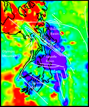
English: Geophysical anomalies and crustal faulting in the Puget Lowland, showing Everett, Tacoma, and Seattle Basins. Bouger gravity anomaly data combined with seismic reflection traveltime data to model rock density at 5 km depth. Blue is the softer, less dense sedimentary deposits, red is the harder, more dense mafic basalt of the Crescent Formation, other colors are intermediate. Black lines are shoreline of Puget Sound, Hood Canal, and the Strait of Juan de Fuca. White dashed lines are crustal faults; faults east of Tacoma Basin are conjectural.
Date Unknown date
Unknown date
; approx. 2005.
Source http://pubs.usgs.gov/pp/pp1661d/pp1661d.pdf
Author U,S. Geological Survey staff
Permission
(Reusing this file)
Public domain
This image is in the public domain in the United States because it only contains materials that originally came from the United States Geological Survey, an agency of the United States Department of the Interior. For more information, see the official USGS copyright policy.

Bahasa Indonesia  català  čeština  Deutsch  eesti  English  español  français  galego  italiano  Nederlands  português  polski  sicilianu  suomi  Tiếng Việt  Türkçe  български  македонски  русский  മലയാളം  한국어  日本語  中文  中文(简体)  中文(繁體)  العربية  فارسی  +/−

From USGS Professional Paper 1661-D (2005), "Crustal Structure of the Cascadia Fore Arc of Washington", fig. 22, p. 34.

File history

Click on a date/time to view the file as it appeared at that time.

Date/TimeThumbnailDimensionsUserComment
current23:13, 24 April 2010Thumbnail for version as of 23:13, 24 April 2010340 × 411 (500 KB)J. Johnson{{Information |Description={{en|1=Geophysical anomalies and crustal faulting in the Puget Lowland, showing Everett, Tacoma, and Seattle Basins. Bouger gravity anomaly data combined with seismic reflection traveltime data to model rock density at 5 km de

No pages embed this file. However pages may still include links to this file.

Global file usage

The following other wikis use this file: