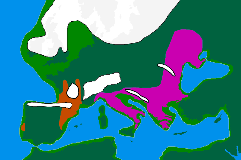
File:Europe20000ya.png
Appearance

Size of this preview: 800 × 532 pixels. Other resolutions: 320 × 213 pixels | 640 × 426 pixels | 1,024 × 681 pixels | 1,280 × 852 pixels | 1,900 × 1,264 pixels.
Original file (1,900 × 1,264 pixels, file size: 98 KB, MIME type: image/png)
File history
Click on a date/time to view the file as it appeared at that time.
| Date/Time | Thumbnail | Dimensions | User | Comment | |
|---|---|---|---|---|---|
| current | 16:00, 12 April 2007 |  | 1,900 × 1,264 (98 KB) | Wobble | Reverted to earlier revision |
| 15:59, 12 April 2007 |  | 1,000 × 665 (106 KB) | Wobble | Reverted to earlier revision | |
| 15:50, 12 April 2007 |  | 1,900 × 1,264 (98 KB) | Wobble | better version, shows refugia better, from Oppenheimer, Out of Eden | |
| 08:13, 28 March 2007 |  | 1,000 × 665 (106 KB) | Dbachmann | shrunk; accounting for Black Sea flood. | |
| 18:59, 25 February 2007 |  | 1,900 × 1,264 (129 KB) | Wobble | {{Information |Description=map of Europe 20,000 years ago. |Source=made from Image:BlankMap-Europe-v3.png, which is GFDL v1.2 by me, outline of coast and extent of ice added by me from information from "After the Ice: A GLoba History" by Steve Mithen. |
File usage
The following page uses this file:
Global file usage
The following other wikis use this file:
- Usage on ar.wikipedia.org
- Usage on bs.wikipedia.org
- Usage on ca.wikipedia.org
- Usage on cs.wikipedia.org
- Usage on de.wikipedia.org
- Usage on en.wikipedia.org
- Europe
- River Thames
- Upper Paleolithic
- Last Glacial Maximum
- Refugium (population biology)
- User:Swid/Sandbox
- Haplogroup I-M170
- Genetic history of Europe
- Last Glacial Maximum refugia
- User:Hans Adler/Sandbox
- User:Wobble/images
- Cro-Magnon
- Epigravettian
- User:Bongan/genetic history of the human race
- Western hunter-gatherer
- User:Baum019/Last Glacial Maximum refugia
- Usage on eo.wikipedia.org
- Usage on es.wikipedia.org
- Usage on eu.wikipedia.org
- Usage on fa.wikipedia.org
- Usage on fi.wikipedia.org
- Usage on fr.wikipedia.org
View more global usage of this file.

