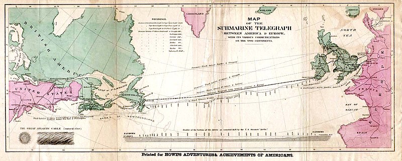
File:Atlantic cable Map.jpg
Appearance

Size of this preview: 800 × 322 pixels. Other resolutions: 320 × 129 pixels | 640 × 257 pixels.
Original file (1,493 × 600 pixels, file size: 163 KB, MIME type: image/jpeg)
File history
Click on a date/time to view the file as it appeared at that time.
| Date/Time | Thumbnail | Dimensions | User | Comment | |
|---|---|---|---|---|---|
| current | 14:35, 29 January 2018 | 1,493 × 600 (163 KB) | Soerfm | Color, brightness | |
| 15:53, 9 March 2006 | 1,493 × 600 (136 KB) | Jailbird | Map of the 1858 Atlantic Cable route from Frank Leslie's Illustrated Newspaper, August 21, 1858 from en:Image:Atlantic_cable_Map.jpg {{PD-Old}} |
File usage
No pages embed this file. However pages may still include links to this file.
Global file usage
The following other wikis use this file:
- Usage on az.wikipedia.org
- Usage on be-tarask.wikipedia.org
- Usage on bs.wikipedia.org
- Usage on ca.wikipedia.org
- Usage on cs.wikipedia.org
- Usage on de.wikipedia.org
- Usage on en.wikipedia.org
- Usage on en.wikibooks.org
- Usage on en.wikivoyage.org
- Usage on eo.wikipedia.org
- Usage on es.wikipedia.org
- Usage on et.wikipedia.org
- Usage on eu.wikipedia.org
- Usage on fa.wikipedia.org
- Usage on fi.wikipedia.org
- Usage on fr.wikipedia.org
- 1866
- Câble sous-marin
- Extel
- Câbles télégraphiques transatlantiques
- Discussion:Câbles télégraphiques transatlantiques
- Wikipédia:Statistiques des anecdotes de la page d'accueil/Visibilité des anecdotes (2021)
- Discussion:Câbles télégraphiques transatlantiques/LSV 19995
- Wikipédia:Statistiques des anecdotes de la page d'accueil/Visibilité des anecdotes (2021)/2021 04
- Projet:Aide et accueil/Twitter/Tweets/archives/avril 2021
- Wikipédia:Le saviez-vous ?/Archives/2021
- Wikipédia:Le Bistro/5 août 2022
- Télégraphie électrique
- Usage on gd.wikipedia.org
- Usage on id.wikipedia.org
- Usage on io.wikipedia.org
- Usage on it.wikipedia.org
- Usage on ja.wikipedia.org
View more global usage of this file.


