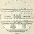
File:Map of Jambudvipa Indian Hindu Cosmology.jpg

Original file (1,914 × 1,888 pixels, file size: 314 KB, MIME type: image/jpeg)
| This is a file from the Wikimedia Commons. The description on its description page there is shown below.
Commons is a freely licensed media file repository. You can help. |
Summary
| DescriptionMap of Jambudvipa Indian Hindu Cosmology.jpg |
Identifier: comprehensivehis01beve Title: A comprehensive history of India, civil, military, and social, from the first landing of the English to the suppression of the Sepoy revolt; including an outline of the early history of Hindoostan Year: 1900 (1900s) Authors: Beveridge, Henry, 1837-1929 Subjects: Publisher: London, Blackie Contributing Library: Robarts - University of Toronto Digitizing Sponsor: University of Toronto
Click here to view book online to see this illustration in context in a browseable online version of this book.
Text Appearing After Image: tASI Map of the JrMMOODEEP. natural consequence, regular intercom-se with it rapidly increased, and both itsfigure and dimensions began to be better understood. Ample evidence of thisis furnished by the works of Strabo and Ptolemy, and yet it cannot be denied,that with all their industry and sagacity, they have rather distorted than de-lineated India. The maritime portion, in particular, is miserably cm-tailed, andits characteristic projection, instead of forming the vertex of a triangle, is con- This map though sufficiently curious, could scarcely be made more intelligible by any amount ofexplanation. It is fanciful throughout, and all the attempts which have been made to find fixed localitiesfor Its cardinal points, and its ranges of mountains, have failed. The ocean surrounding Jummoodeep is the only one which looks like reality, because it is said to consist of salt water. The other six oceai.sbeyond it consist m succession of milk, milk curds, ghee or clarified butter, sugar-can
|
| Source | Image from page 35 of "A comprehensive history of India, civil, military, and social, from the first landing of the English to the suppression of the Sepoy revolt; including an outline of the early history of Hindoostan" (1900) |
| Author | Internet Archive Book Images |
| Permission (Reusing this file) |
Internet Archive Book Images @ Flickr Commons |
Licensing
This image was taken from Flickr's The Commons. The uploading organization may have various reasons for determining that no known copyright restrictions exist, such as: No known copyright restrictionsNo restrictionshttps://www.flickr.com/commons/usage/false
More information can be found at https://flickr.com/commons/usage/. Please add additional copyright tags to this image if more specific information about copyright status can be determined. See Commons:Licensing for more information. |
| This image was originally posted to Flickr by Internet Archive Book Images at https://www.flickr.com/photos/126377022@N07/14578079870. It was reviewed on 4 April 2015 by FlickreviewR and was confirmed to be licensed under the terms of the No known copyright restrictions. |
4 April 2015
Captions
Items portrayed in this file
depicts
some value
image/jpeg
File history
Click on a date/time to view the file as it appeared at that time.
| Date/Time | Thumbnail | Dimensions | User | Comment | |
|---|---|---|---|---|---|
| current | 20:38, 4 April 2015 |  | 1,914 × 1,888 (314 KB) | Nizil Shah | Transferred from Flickr via Flickr2Commons |
File usage
The following page uses this file:
Global file usage
The following other wikis use this file:
- Usage on bn.wikipedia.org
- Usage on en.wikipedia.org
- Usage on ta.wikipedia.org
- Usage on ur.wikipedia.org