File:Venus dome 3D.jpg
Jump to navigation
Jump to search

Size of this preview: 750 × 600 pixels. Other resolutions: 300 × 240 pixels | 600 × 480 pixels | 960 × 768 pixels | 1,280 × 1,024 pixels | 2,560 × 2,048 pixels | 5,000 × 4,000 pixels.
Original file (5,000 × 4,000 pixels, file size: 1.17 MB, MIME type: image/jpeg)
| This is a file from the Wikimedia Commons. The description on its description page there is shown below.
Commons is a freely licensed media file repository. You can help. |
Summary
| Description |
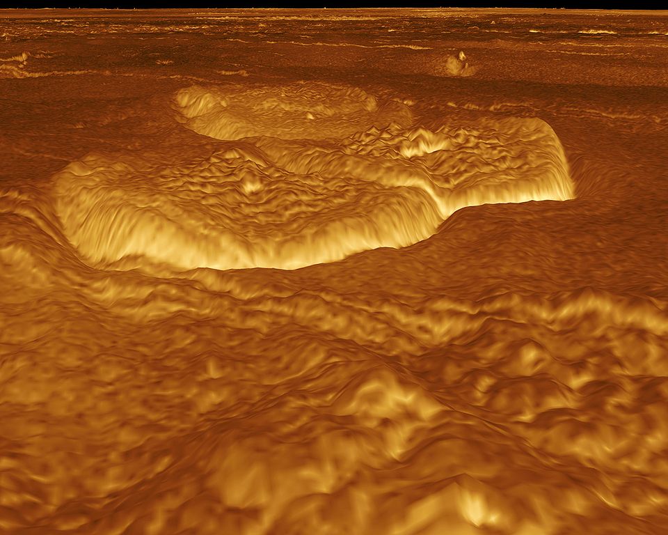
English: A portion of the eastern edge of Alpha Regio is displayed in this three-dimensional perspective view of the surface of Venus. The viewpoint is located at approximately 30 degrees south latitude, 11.8 degrees east longitude at an elevation of 2.4 kilometers (3.8 miles). The view is to the northeast at the center of an area containing seven circular dome-like hills. The average diameter of the hills is 25 kilometers (15 miles) with maximum heights of 750 meters (2,475 feet). Three of the hills are visible in the center of the image. Fractures on the surrounding plains are both older and younger than the domes. The hills may be the result of viscous or thick eruptions of lava coming from a vent on the relatively level ground, allowing the lava to flow in an even lateral pattern. The concentric and radial fracture patterns on their surfaces suggests that a chilled outer layer formed, then further intrusion in the interior stretched the surface. An alternative interpretation is that domes are the result of shallow intrusions of molten lava, causing the surface to rise. If they are intrusive, then magma withdrawal near the end of the eruptions produced the fractures. The bright margins possibly indicate the presence of rock debris or talus at the slopes of the domes. Resolution of the Magellan data is about 120 meters (400 feet). Magellan's synthetic aperture radar is combined with radar altimetry to develop a three-dimensional map of the surface. A perspective view is then generated from the map. Simulated color and a process called radar-clinometry are used to enhance small-scale structures. The simulated hues are based on color images recorded by the Soviet Venera 13 and 14 spacecraft. The image was produced by the JPL Multimission Image Processing Laboratory by Eric De Jong, Jeff Hall, Myche McAuley, and Randy Kirk of the United States Geological Survey, and is a single frame from the movie released at the May 29, 1991 Magellan news conference.
Čeština: Útvary na planetě Venuši, východně od Alpha Regio. Obraz byl vytvořen v laboratoři JPL Multimission Image Processing Laboratory, autory jsou Eric De Jong, Jeff Hall, Myche McAuley a Randy Kirk. Obraz byl získán metodou radarové klinometrie (měření sklonu) a je vyobrazen v nepravých barvách. |
| Date | |
| Source | http://photojournal.jpl.nasa.gov/catalog/PIA00246 |
| Author | NASA, JPL Multimission Image Processing Laboratory, U.S Geological Survey |
| Permission (Reusing this file) |
http://nssdc.gsfc.nasa.gov/photo_gallery/photogallery-faq.html#use |
This image or video was catalogued by Jet Propulsion Laboratory of the United States National Aeronautics and Space Administration (NASA) under Photo ID: PIA00246. This tag does not indicate the copyright status of the attached work. A normal copyright tag is still required. See Commons:Licensing. Other languages:
|
Licensing
| This file is in the public domain in the United States because it was solely created by NASA. NASA copyright policy states that "NASA material is not protected by copyright unless noted". (See Template:PD-USGov, NASA copyright policy page or JPL Image Use Policy.) | ||
 |
Warnings:
|
File history
Click on a date/time to view the file as it appeared at that time.
| Date/Time | Thumbnail | Dimensions | User | Comment | |
|---|---|---|---|---|---|
| current | 21:13, 1 September 2005 | | 5,000 × 4,000 (1.17 MB) | Bricktop | larger |
| 20:30, 1 September 2005 |  | 645 × 516 (45 KB) | Lotse | *'''Original Caption Released with Image:''' A portion of the eastern edge of Alpha Regio is displayed in this three-dimensional perspective view of the surface of Venus. The viewpoint is located at approximately 30 degrees south latitude, 11.8 degrees e |
File usage
The following 3 pages use this file:
Global file usage
The following other wikis use this file:
- Usage on ar.wikipedia.org
- Usage on ca.wikipedia.org
- Usage on cs.wikipedia.org
- Usage on de.wikipedia.org
- Usage on en.wikipedia.org
- Usage on fr.wikipedia.org
- Usage on hy.wikipedia.org
- Usage on ja.wikipedia.org
- Usage on mk.wikipedia.org
- Usage on nl.wikipedia.org
- Usage on pl.wiktionary.org
- Usage on ru.wikipedia.org
- Usage on uk.wikipedia.org
- Usage on zh.wikipedia.org