File:Rio Negro meanders.JPG
Jump to navigation
Jump to search

Size of this preview: 800 × 531 pixels. Other resolutions: 320 × 213 pixels | 640 × 425 pixels | 1,024 × 680 pixels | 1,280 × 850 pixels | 2,560 × 1,700 pixels | 4,288 × 2,848 pixels.
Original file (4,288 × 2,848 pixels, file size: 1.18 MB, MIME type: image/jpeg)
| This is a file from the Wikimedia Commons. The description on its description page there is shown below.
Commons is a freely licensed media file repository. You can help. |
| Description |
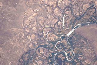
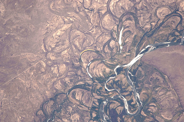
English: Country or Geographic Name: ARGENTINA
Features: RIO NEGRO, COLONEL JOSEFA AREA, FLOOD PLAIN Center Point Latitude: -39.8 Center Point Longitude: -65.4 |
|||||
| Date | Date: 20100104 (YYYYMMDD)GMT Time: 175502 (HHMMSS) | |||||
| Source | ftp://eol.jsc.nasa.gov/EFS_highres_ISS022_ISS022-E-19513.JPG via http://climate.nasa.gov/blogs/index.cfm?FuseAction=ShowBlog&NewsID=462 | |||||
| Author | NASA Astronaut photograph ISS022-E-19513. | |||||
| Permission (Reusing this file) |
|
|||||
| Other versions | See http://eol.jsc.nasa.gov/scripts/sseop/photo.pl?mission=ISS022&roll=E&frame=19513 |

File history
Click on a date/time to view the file as it appeared at that time.
| Date/Time | Thumbnail | Dimensions | User | Comment | |
|---|---|---|---|---|---|
| current | 17:13, 16 November 2014 | | 4,288 × 2,848 (1.18 MB) | Ras67 | high resolution |
| 15:53, 2 March 2011 |  | 1,000 × 662 (689 KB) | Tillman | {{Information |Description ={{en|1=Country or Geographic Name: ARGENTINA Features: RIO NEGRO, COLONEL JOSEFA AREA, FLOOD PLAIN Center Point Latitude: -39.8 Center Point Longitude: -65.4 }} |Source =ftp://eol.jsc.nasa.gov/EFS_highres_ISS022_ISS0 |
File usage
The following page uses this file:
Global file usage
The following other wikis use this file:
- Usage on af.wikipedia.org
- Usage on ar.wikipedia.org
- Usage on ba.wikipedia.org
- Usage on bh.wikipedia.org
- Usage on bn.wikipedia.org
- Usage on ca.wikipedia.org
- Usage on el.wikipedia.org
- Usage on en.wikipedia.org
- Usage on et.wikipedia.org
- Usage on fr.wikipedia.org
- Usage on he.wikipedia.org
- Usage on hy.wikipedia.org
- Usage on it.wikipedia.org
- Usage on it.wikibooks.org
- Usage on it.wikiversity.org
- Usage on ja.wikipedia.org
- Usage on pt.wikipedia.org
- Usage on ru.wikipedia.org
- Usage on sr.wikipedia.org
- Usage on th.wikipedia.org
- Usage on uk.wikipedia.org
- Usage on www.wikidata.org
- Usage on zh.wikipedia.org