File:PIA21612 - Wandering Poles of Enceladus, Figure 1.jpg

Original file (2,400 × 1,200 pixels, file size: 1.46 MB, MIME type: image/jpeg)
| This is a file from the Wikimedia Commons. The description on its description page there is shown below.
Commons is a freely licensed media file repository. You can help. |
Summary
| Description |
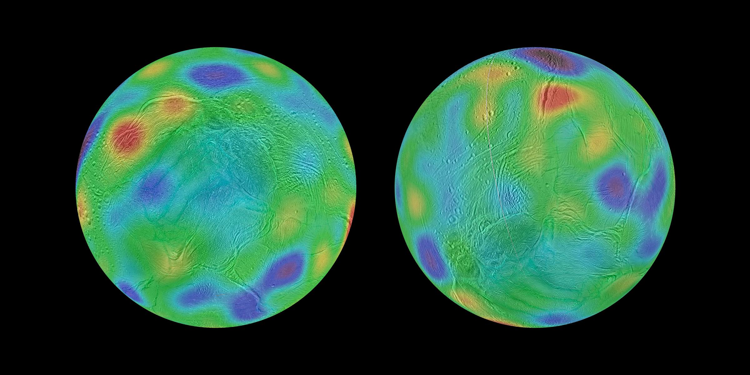
English: Working with image data from NASA's Cassini mission, researchers have found evidence that Saturn's moon Enceladus may have tipped over, reorienting itself so that terrain closer to its original equator was relocated to the poles. This phenomenon is known as true polar wander.
Researchers discovered a chain of basins across the surface of Enceladus along with a pair of depressions that line up with an equator and poles, respectively, if the moon's axis of rotation was reoriented by about 55 degrees of latitude. These maps look toward the icy moon's southern hemisphere, with colors representing highs and lows. Purple represents the lowest elevations, while red represents the highest. The map at left shows the surface of Enceladus in its possible ancient orientation, millions of years ago. The chain of basins representing topographic lows can be seen in blue and purple, running along the equator, with an additional low region around the original south pole. The region that encloses the moon's currently active south polar terrain, with its long, linear "tiger stripe" fractures, would have been at middle latitudes just south of the equator. The map at right shows the current orientation of Enceladus. The Cassini mission is a cooperative project of NASA, ESA (the European Space Agency) and the Italian Space Agency. The Jet Propulsion Laboratory, a division of the California Institute of Technology in Pasadena, California, manages the mission for NASA's Science Mission Directorate, Washington. The Cassini orbiter and its two onboard cameras were designed, developed and assembled at JPL. The imaging operations center is based at the Space Science Institute in Boulder, Colorado. |
| Date | Taken on 30 May 2017 (published) |
| Source | Catalog page · Full-res (JPEG · TIFF) |
| Author | NASA/JPL-Caltech/Space Science Institute |
| Other versions |
|


This image or video was catalogued by Jet Propulsion Laboratory of the United States National Aeronautics and Space Administration (NASA) under Photo ID: PIA21612. This tag does not indicate the copyright status of the attached work. A normal copyright tag is still required. See Commons:Licensing. Other languages:
|
 |
This media is a product of the Cassini Solstice Mission Credit and attribution belongs to the mission team, if not already specified in the "author" row |
Licensing
| This file is in the public domain in the United States because it was solely created by NASA. NASA copyright policy states that "NASA material is not protected by copyright unless noted". (See Template:PD-USGov, NASA copyright policy page or JPL Image Use Policy.) | ||
 |
Warnings:
|
File history
Click on a date/time to view the file as it appeared at that time.
| Date/Time | Thumbnail | Dimensions | User | Comment | |
|---|---|---|---|---|---|
| current | 03:48, 2 June 2017 | | 2,400 × 1,200 (1.46 MB) | PhilipTerryGraham | User created page with UploadWizard |
File usage
The following page uses this file:
Global file usage
The following other wikis use this file:
- Usage on beta.wikiversity.org