File:Martian Dust Devil Trails.jpg
Original file (2,560 × 1,920 pixels, file size: 5.59 MB, MIME type: image/jpeg)
| This is a file from the Wikimedia Commons. The description on its description page there is shown below.
Commons is a freely licensed media file repository. You can help. |
Summary
| Description |
Català: Imatge presa per la Sonda orbital d'exploració de Mart mostrant traces negres formades per remolins de pols creuant raigs de llum sobre la superfície de Mart. Els vòrtexs, que poden tenir fins a 8 km d'alçada, aixequen una fina capa de pols i deixen al descobert la sorra més densa i fosca.
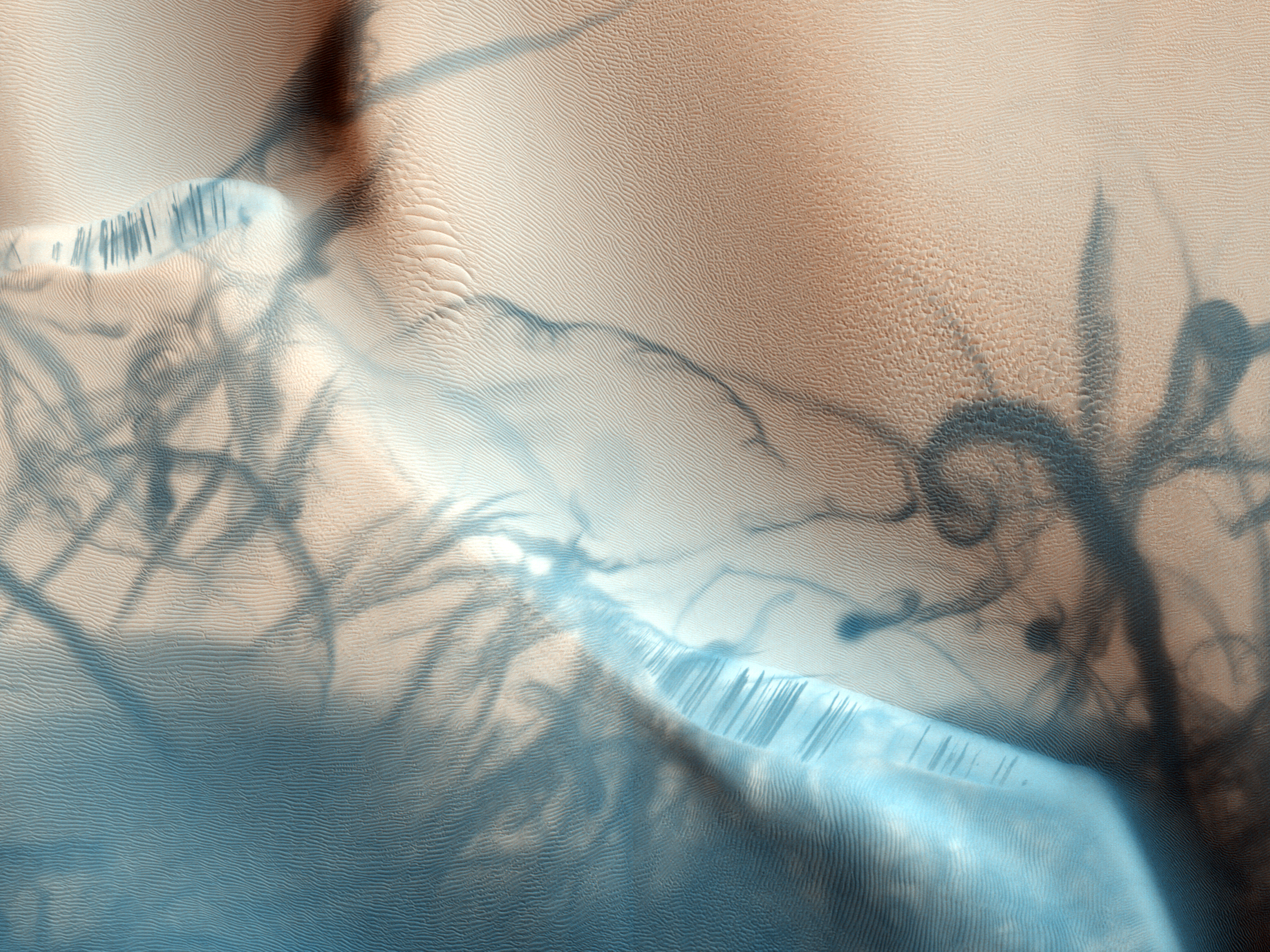
English: This portion of a recent high-resolution picture from the HiRISE camera on board the Mars Reconnaissance Orbiter shows twisting dark trails criss-crossing light coloured terrain on the Martian surface. Newly formed trails like these had presented researchers with a tantalizing Martian mystery but are now known to be the work of miniature wind vortices known to occur on the red planet - Martian dust devils. Such spinning columns of rising air heated by the warm surface are also common in dry and desert areas on planet Earth. Typically lasting only a few minutes, dust devils becoming visible as they pick up loose red-coloured dust leaving the darker and heavier sand beneath intact. On Mars, dust devils can be up to 8 kilometres high. Dust devils have been credited with unexpected cleanings of Mars rover solar panels.
Français : Traces noires laissées par des tourbillons de poussière sur la surface de Mars. Ces traces ont longtemps questionné les planétologues, mais on sait aujourd'hui qu'elle sont dues à des tourbillons qui soulèvent une fine couche de poussière claire et laissent apparaître du sable, plus dense et plus sombre. De tels tourbillons existent aussi sur Terre dans les déserts et les zones sèches. Sur Mars, de tels tourbillons peuvent faire jusqu'à 8 km de haut (1 km sur Terre). De tels tourbillons ont parfois nettoyé les panneaux solaires des rovers martiens. Photo prise par la sonde Mars Reconnaissance Orbiter de la NASA.
Русский: Этот фотографический снимок Марсианской поверхности с перекрещивающимися закрученными темными дорожками на фоне светлого рельефа сделан с борта разведывательного орбитального спутника Марса (Mars Reconnaissance Orbiter) камерой высокого разрешения HiRISE. Образование таких дорожек, долго остававшееся одной из Марсианских загадок, ныне объяснено исследователями: это следы марсианских "пылевых дьяволов"-смерчей, которые часто образуются на поверхности красной планеты. Пылевые вихри, закручивающиеся вокруг столбов восходящих от раскалённой поверхности потоков воздуха, случаются часто и на Земле в засушливых и пустынных районах. Обычно длящиеся всего несколько минут, марсианские "пылевые дьяволы" втягивают с поверхности в вихревую воронку лёгкие сыпучие породы красного цвета, не захватывая более тёмные тяжелые пески, которые и формируют дорожки следов от смерчей. "Пылевые дьяволы" на Марсе могут достигать 8 км в высоту (земные - до 1 км). Считается, что панели солнечных батарей марсоходов избавлялись от загрязнений именно благодаря "пылевым дьяволам". |
| Date | Taken on 24 August 2009 |
| Source | http://www.uahirise.org/ESP_014426_2070 |
| Author | NASA/JPL/University of Arizona |
| Permission (Reusing this file) |
http://www.uahirise.org/media/usage.php |
|

This image was selected as picture of the day on Wikimedia Commons for 24 March 2010. It was captioned as follows: English: This picture from the HiRISE camera on board the Mars Reconnaissance Orbiter shows twisting dark trails criss-crossing light coloured terrain on the Martian surface. Newly formed trails like these had presented researchers with a tantalizing Martian mystery but are now known to be the work of miniature wind vortices known to occur on the red planet. Other languages:
Català: Imatge presa per la Sonda orbital d'exploració de Mart mostrant traces negres formades per remolins de pols creuant raigs de llum sobre la superfície de Mart. Els vòrtexs, que poden tenir fins a 8 km d'alçada, aixequen una fina capa de pols i deixen al descobert la sorra més densa i fosca. Čeština: Obrázek z kamery HiRISE na sondě Mars Reconnaissance Orbiter ukazuje povrch Marsu; černé stopy jsou výsledkem drobných větrných vírů Dansk: Billede fra HiRISE-kameraet i Mars Reconnaissance Orbiter visende snoede mørke linjer på kryds og tværs over den lyse overflade på Mars. Nydannede linjer af denne art var et mysterium, indtil det blev opdaget, at de dannes som følge af små vindhvirvler på den røde planet. Deutsch: Spuren von Staubteufeln auf der Marsoberfläche. Bild der HiRISE-Kamera des Mars Reconnaissance Orbiters English: This picture from the HiRISE camera on board the Mars Reconnaissance Orbiter shows twisting dark trails criss-crossing light coloured terrain on the Martian surface. Newly formed trails like these had presented researchers with a tantalizing Martian mystery but are now known to be the work of miniature wind vortices known to occur on the red planet. Español: Imagen obtenida con la cámara HiRISE a bordo de la sonda Mars Reconnaissance Orbiter mostrando trazos oscuros que podrían ser vórtices de polvo en la superfície de Marte. Italiano: Diavoli di sabbia su Marte: i vortici d'aria spazzano via la polvere rossa superficiale scoprendo la sabbia più scura sottostante. Questa foto è stata scattata dal telescopio HiRISE installato sulla sonda Mars Reconnaissance Orbiter Magyar: Örvénylő sötét nyomok a Mars világosabb színű felszínén, a Mars Reconnaissance Orbiter HiRISE kamerájának felvételén. Az ehhez hasonló nyomok létrejöttét korábban rejtély övezte, melyet megfejtettek: kis forgószelek és porördögök útvonalait mutatják. Nederlands: Dit beeld dat werd genomen door de HiRISE-camera aan boord van de Mars Reconnaissance Orbiter toont zigzaggende donkere sporen over lichtgekleurd terrein op het Martiaanse oppervlak. Dergelijke sporen stelden wetenschappers aanvankelijk voor een raadsel, maar bleken later het werk te zijn van stofstormen ('Martiaanse stofduivels') die optreden op de rode planeet en soms hoogten van 8 kilometer kunnen bereiken. Português: Imagem obtida com a sonda Mars Reconnaissance Orbiter mostrando efeitos similares a vórtices na superfície de Marte. Беларуская (тарашкевіца): Фатаздымак камэры HiRISE на спадарожніку Mars Reconnaissance Orbiter. Падобныя пэйзажы былі загадкай для навукоўцаў, але цяпер вядома, што гэта вынікі віхроў на чырвонай плянэце. Македонски: Слика на површината на Марс од Марсовскиот извиднички орбитер. На сликата се забележуваат темни извиени траги. Ваквите траги претставувале голема енигма за научниците, сè додека не било откриено дека се работи за траги од минијатурни ветерни вртлози. Українська: Марсіанський пейзаж, сфотографований марсіанським розвідувальним супутником Mars Reconnaissance Orbiter в серпні 2009. (Темні (сині) сліди — піщані вихори). বাংলা : মঙ্গলগ্রহের কক্ষপথে অবস্থিত হাইরাইজ ক্যামেরা থেকে দৃশ্যমান মঙ্গল ভূখণ্ডে অবস্থিত গাঢ় রংয়ের পাকানো ট্রেইলের চিত্র। গবেষকরা নতুন তৈরি হওয়া এসব ট্রেইল মঙ্গলে এককালে সৃষ্টি হওয়া বাতাসের ঘূর্ণাবর্তের ফলাফল বলে মনে করছেন। 日本語: マーズ・リコネッサンス・オービターに搭載されたHiRISEカメラで撮影された火星の表面。明るい色の地形の中を、暗い色の痕跡が縦横にうねって走っているが、これは火星上に発生する旋風によって形成されたものと考えられている。 中文: 本照片由火星勘测轨道飞行器上的HiRISE照相机拍摄,展现了火星表面上浅色地带上深色的冲横交错的痕迹。新形成的这种痕迹曾经被研究人员认为是一个诱人的火星之谜,如今已知是旋风对这个红色星球的作用。 中文(繁體): 本照片由火星偵察軌道器上的HiRISE照相機拍攝,展現了火星表面的淺色地帶上縱橫交錯的深色痕迹。新形成的這種痕迹曾經被研究人員認為是一個誘人的火星之謎,如今已知是旋風對這個紅色星球的作用。 |
Latitude (centered): 26.7 °. Longitude (East): 62.8 °. Range to target site: 284.9 km. Original image scale range: 57.0 cm/pixel (with 2 x 2 binning) so objects ~171 cm across are resolved. Map projected scale: 50 cm/pixel and north is up. Map projection: EQUIRECTANGULAR. Emission angle: 0.3 °. Phase angle: 51.3 °. Solar incidence angle: 51 °, with the Sun about 39 ° above the horizon. Solar longitude: 326.8 °, Northern Winter.
Licensing
| This file is in the public domain in the United States because it was solely created by NASA. NASA copyright policy states that "NASA material is not protected by copyright unless noted". (See Template:PD-USGov, NASA copyright policy page or JPL Image Use Policy.) | ||
 |
Warnings:
|
File history
Click on a date/time to view the file as it appeared at that time.
| Date/Time | Thumbnail | Dimensions | User | Comment | |
|---|---|---|---|---|---|
| current | 11:14, 21 October 2009 | | 2,560 × 1,920 (5.59 MB) | Originalwana | {{Information |Description={{en|1=This portion of a recent high-resolution picture from the HiRISE camera on board the Mars Reconnaissance Orbiter shows twisting dark trails criss-crossing light coloured terrain o |
File usage
The following 2 pages use this file:
Global file usage
The following other wikis use this file:
- Usage on bn.wikipedia.org
- Usage on bn.wikibooks.org
- Usage on crh.wikipedia.org
- Usage on cs.wikipedia.org
- Usage on cv.wikipedia.org
- Usage on el.wikipedia.org
- Usage on en.wikipedia.org
- Dust devil
- Talk:Dust devil
- HiRISE
- User talk:JJ Harrison/Archive4
- Wikipedia:Featured pictures/Natural phenomena/Atmospheric optics
- Martian soil
- User:Originalwana
- Wikipedia:Featured pictures thumbs/21
- Wikipedia:Featured picture candidates/File:Martian Dust Devil Trails.jpg
- Wikipedia:Featured picture candidates/December-2009
- Wikipedia:Wikipedia Signpost/2009-12-14/Features and admins
- User talk:JJ Harrison/Archive3
- Wikipedia:Picture of the day/June 2011
- Template:POTD/2011-06-24
- Wikipedia:Main Page history/2011 June 24
- Wikipedia:Wikipedia Signpost/2009-12-14/SPV
- Wikipedia:Wikipedia Signpost/Single/2009-12-14
- Usage on es.wikipedia.org
- Usage on et.wikipedia.org
- Usage on fa.wikipedia.org
- Usage on fa.wikibooks.org
- Usage on fr.wikipedia.org
- Usage on hu.wikipedia.org
- Usage on hy.wikibooks.org
- Usage on it.wikipedia.org
- Usage on ko.wikipedia.org
View more global usage of this file.