File:Jamaica-CIA WFB Map.png
Jump to navigation
Jump to search
No higher resolution available.
Jamaica-CIA_WFB_Map.png (634 × 322 pixels, file size: 12 KB, MIME type: image/png)
| This is a file from the Wikimedia Commons. The description on its description page there is shown below.
Commons is a freely licensed media file repository. You can help. |
Summary
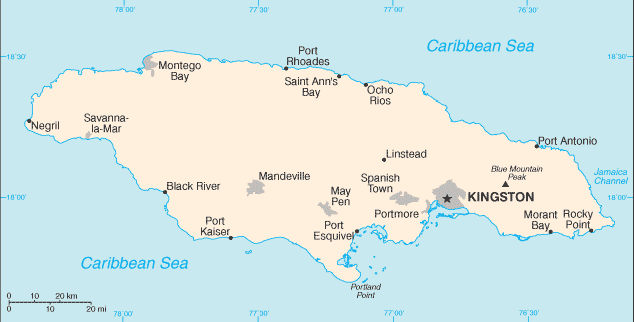
| Description | Map of Jamaica showing major cities. | |||
| Date | ||||
| Source | CIA, The World Factbook, 2006 | |||
| Author | CIA | |||
| Permission (Reusing this file) |
|

File history
Click on a date/time to view the file as it appeared at that time.
| Date/Time | Thumbnail | Dimensions | User | Comment | |
|---|---|---|---|---|---|
| current | 08:32, 30 January 2006 | | 634 × 322 (12 KB) | Hoshie | Updated map of Jamaica from the CIA World Factbook, 10 Jan 06 rev: http://www.cia.gov/cia/publications/factbook/maps/jm-map.gif |
| 09:15, 27 March 2005 |  | 673 × 344 (8 KB) | Wolfman~commonswiki | {{CIA-map}} |
File usage
The following page uses this file:
Global file usage
The following other wikis use this file:
- Usage on arz.wikipedia.org
- Usage on bn.wikipedia.org
- Usage on ca.wikipedia.org
- Usage on de.wikipedia.org
- Usage on en.wikipedia.org
- Usage on fa.wikipedia.org
- Usage on gom.wikipedia.org
- Usage on hu.wikipedia.org
- Usage on id.wikipedia.org
- Usage on ja.wikipedia.org
- Usage on kn.wikipedia.org
- Usage on lt.wiktionary.org
- Usage on ml.wikipedia.org
- Usage on mr.wikipedia.org
- Usage on pl.wikipedia.org
- Usage on simple.wikipedia.org
- Usage on si.wikipedia.org
- Usage on sl.wikipedia.org
- Usage on sv.wikipedia.org
- Usage on uz.wikipedia.org
- Usage on zh.wikipedia.org