File:Fertile Crescent map.png
Jump to navigation
Jump to search

Size of this preview: 488 × 600 pixels. Other resolutions: 195 × 240 pixels | 391 × 480 pixels | 625 × 768 pixels | 833 × 1,024 pixels | 1,988 × 2,443 pixels.
Original file (1,988 × 2,443 pixels, file size: 717 KB, MIME type: image/png)
| This is a file from the Wikimedia Commons. The description on its description page there is shown below.
Commons is a freely licensed media file repository. You can help. |
{{subst:proposed deletion|concern=Incorrect details as well as political motivated terms. See discussion please remove image}}

|
File:Map of fertile crescent.svg is a vector version of this file. It should be used in place of this PNG file when not inferior.
File:Fertile Crescent map.png → File:Map of fertile crescent.svg
For more information, see Help:SVG. |
 |
Summary
| Description |
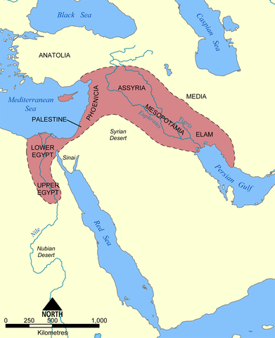
English: This map shows the location and extent of the Fertile Crescent, a region in the Middle East incorporating Ancient Egypt; the Levant; and Mesopotamia.
Français : Carte en anglais du Croissant fertile, région du Moyen-Orient incluant l'Égypte antique, le Levant et la Mésopotamie où a débuté la civilisation. |
| Date | |
| Source |
Own work This image was based on a similar map from the 1994 edition of the Encyclopedia Britannica. |
| Author | User:NormanEinstein |
| Other versions |
[]
See also:
|


Licensing
I, the copyright holder of this work, hereby publish it under the following licenses:

|
Permission is granted to copy, distribute and/or modify this document under the terms of the GNU Free Documentation License, Version 1.2 or any later version published by the Free Software Foundation; with no Invariant Sections, no Front-Cover Texts, and no Back-Cover Texts. A copy of the license is included in the section entitled GNU Free Documentation License. |
| This file is licensed under the Creative Commons Attribution-Share Alike 3.0 Unported license. | ||
| ||
| This licensing tag was added to this file as part of the GFDL licensing update. |
You may select the license of your choice.
derivative works
Derivative works of this file:
File history
Click on a date/time to view the file as it appeared at that time.
| Date/Time | Thumbnail | Dimensions | User | Comment | |
|---|---|---|---|---|---|
| current | 18:28, 17 June 2010 | | 1,988 × 2,443 (717 KB) | Ras67 | cropped and squeezed |
| 20:30, 21 December 2005 |  | 2,000 × 2,454 (990 KB) | NormanEinstein | This map shows the location and extent of the '''Fertile Crescent''', a region in the Middle East incorporating Ancient Egypt, the Levant, and Mesopotamia where civilisation started. Created by NormanEinstein, December 21, 2005. {{GFDL-self}} [[Categor |
File usage
The following page uses this file:
Global file usage
The following other wikis use this file:
- Usage on azb.wikipedia.org
- Usage on az.wikipedia.org
- Usage on bg.wikipedia.org
- Usage on bn.wikipedia.org
- Usage on cs.wikipedia.org
- Usage on en.wikipedia.org
- Usage on en.wiktionary.org
- Usage on et.wikipedia.org
- Usage on fa.wikipedia.org
- Usage on fi.wikipedia.org
- Usage on fr.wikipedia.org
- Usage on gl.wikipedia.org
- Usage on he.wikipedia.org
- Usage on hu.wikipedia.org
- Usage on id.wikipedia.org
- Usage on it.wikipedia.org
- Usage on ko.wikipedia.org
- Usage on lv.wikipedia.org
- Usage on mk.wikipedia.org
- Usage on mwl.wikipedia.org
- Usage on nn.wikipedia.org
- Usage on no.wikipedia.org
- Usage on pl.wikipedia.org
- Usage on pl.wiktionary.org
- Usage on pt.wikibooks.org
- Usage on ro.wikipedia.org
- Usage on sh.wikipedia.org
- Usage on simple.wikipedia.org
- Usage on sk.wikipedia.org
- Usage on sq.wikipedia.org
- Usage on sv.wikipedia.org
View more global usage of this file.