File:Fault in Seppap Gorge Morocco.jpg
Jump to navigation
Jump to search

Size of this preview: 450 × 600 pixels. Other resolutions: 180 × 240 pixels | 360 × 480 pixels | 576 × 768 pixels | 768 × 1,024 pixels | 1,944 × 2,592 pixels.
Original file (1,944 × 2,592 pixels, file size: 2.02 MB, MIME type: image/jpeg)
| This is a file from the Wikimedia Commons. The description on its description page there is shown below.
Commons is a freely licensed media file repository. You can help. |
Summary
| Description |
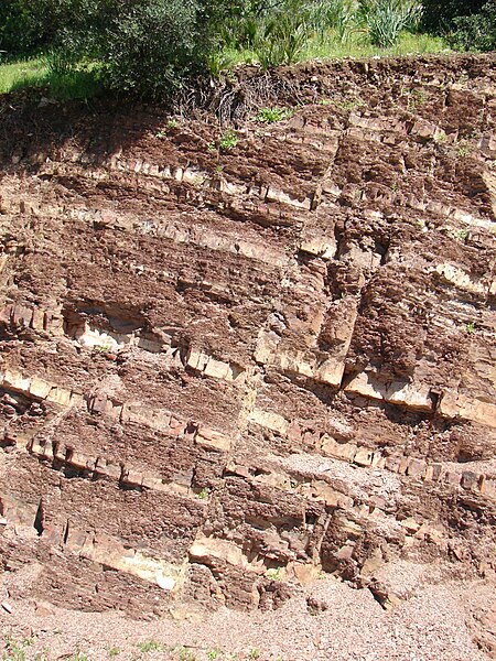
English: Alternating layers of mudstone and sandstone of the Sidi Bettache Basin of Carboniferous age, cut by a normal fault in Seppap Gorge near Sidi Bettache, Morocco. The outcrop is about 5 metres high. There has been about 15 to 20 centimetres of movement along the fault. |
| Date | |
| Source | http://www.geodiversite.net/media1015 |
| Author | Franck Bouttemy http://www.geodiversite.net/auteur197 |
| Camera location | | View this and other nearby images on: OpenStreetMap |
|---|
Licensing
This file is licensed under the Creative Commons Attribution-Share Alike 3.0 Unported license.
- You are free:
- to share – to copy, distribute and transmit the work
- to remix – to adapt the work
- Under the following conditions:
- attribution – You must give appropriate credit, provide a link to the license, and indicate if changes were made. You may do so in any reasonable manner, but not in any way that suggests the licensor endorses you or your use.
- share alike – If you remix, transform, or build upon the material, you must distribute your contributions under the same or compatible license as the original.
This file, which was originally posted to
http://www.geodiversite.net/media1015, was reviewed on 13 December 2013 by reviewer Leoboudv, who confirmed that it was available there under the stated license on that date.
|
File history
Click on a date/time to view the file as it appeared at that time.
| Date/Time | Thumbnail | Dimensions | User | Comment | |
|---|---|---|---|---|---|
| current | 19:55, 13 December 2013 | | 1,944 × 2,592 (2.02 MB) | GeoWriter | User created page with UploadWizard |
File usage
The following page uses this file:
Global file usage
The following other wikis use this file:
- Usage on bn.wikipedia.org
- Usage on de.wikipedia.org
- Usage on en.wikipedia.org
- Usage on hr.wikipedia.org
- Usage on ja.wikibooks.org
- Usage on nl.wikibooks.org
- Usage on pt.wikipedia.org
- Usage on vi.wikipedia.org