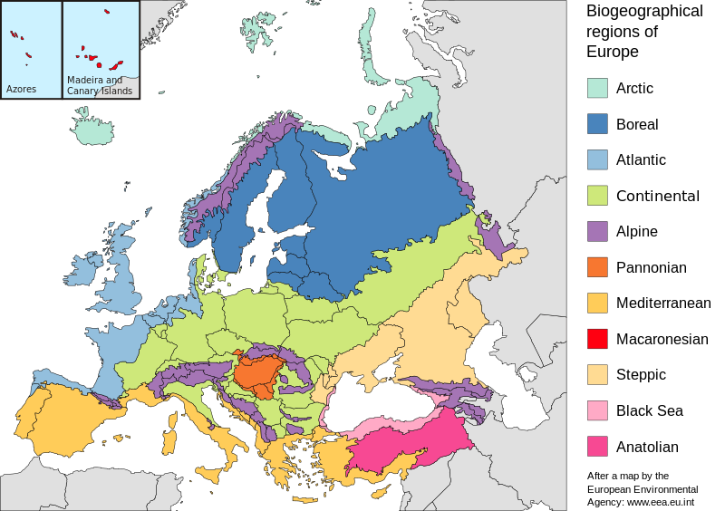
File:Europe biogeography countries en.svg
Jump to navigation
Jump to search

Size of this PNG preview of this SVG file: 800 × 564 pixels. Other resolutions: 320 × 225 pixels | 640 × 451 pixels | 1,024 × 722 pixels | 1,280 × 902 pixels | 2,560 × 1,804 pixels | 3,535 × 2,491 pixels.
Original file (SVG file, nominally 3,535 × 2,491 pixels, file size: 710 KB)
File history
Click on a date/time to view the file as it appeared at that time.
| Date/Time | Thumbnail | Dimensions | User | Comment | |
|---|---|---|---|---|---|
| current | 20:41, 19 July 2010 |  | 3,535 × 2,491 (710 KB) | Malus Catulus | Changed according graphic lab request: removed frame, hopefully fixed text, fixed some other stuff |
| 10:48, 23 May 2006 |  | 3,600 × 2,610 (876 KB) | Tintazul | {{Tintazul| |Description=Map of the biogeographic regions of Europe, after EEA's map. Shows both country and biogeographical region boundaries. Legend in English. SVG format. |Date=20 May 2006 |Source=Made with Inkscape from [[:Image:Biogeographical Regi |
File usage
The following page uses this file:
Global file usage
The following other wikis use this file:
- Usage on ar.wikipedia.org
- Usage on azb.wikipedia.org
- Usage on az.wikipedia.org
- Usage on beta.wikiversity.org
- Usage on bn.wikipedia.org
- Usage on bs.wikipedia.org
- Usage on cs.wikipedia.org
- Usage on da.wikipedia.org
- Usage on el.wikipedia.org
- Usage on en.wikipedia.org
- Geography of Armenia
- Europe
- Biogeography
- Pannonian Basin
- Template talk:Greek diaspora
- User:Engram
- Fauna of Europe
- User:Whytecypress/UserboxCaucasian
- Portal:Maps/Maps/Geographic
- User talk:BadYodels
- Portal:Maps/Maps/Geographic/6
- User:Kaarel/sandbox/Fauna of Europe
- List of butterflies of Europe
- Portal:Maps
- Mediterranean Biogeographic Region
- Arctic Biogeographic Region
- Boreal Biogeographic Region
- Biogeographic regions of Europe
- Atlantic Biogeographic Region
- Continental Biogeographic Region
- Anatolian Biogeographic Region
- Black Sea Biogeographic Region
- Macaronesian Biogeographic Region
- Alpine Biogeographic Region
- Pannonian Biogeographic Region
- Steppic Biogeographic Region
- Usage on eo.wikipedia.org
- Usage on es.wikipedia.org
- Usage on fa.wikipedia.org
- Usage on ga.wikipedia.org
- Usage on gl.wikipedia.org
- Usage on hy.wikipedia.org
- Usage on ja.wikipedia.org
View more global usage of this file.

