File:East Pacific Rise seafloor magnetic profile - observed vs calculated.png
Jump to navigation
Jump to search

No higher resolution available.
East_Pacific_Rise_seafloor_magnetic_profile_-_observed_vs_calculated.png (361 × 304 pixels, file size: 20 KB, MIME type: image/png)
| This is a file from the Wikimedia Commons. The description on its description page there is shown below.
Commons is a freely licensed media file repository. You can help. |
Summary
| Description |
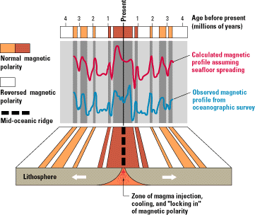
A comparison of the observed magnetic profile for the seafloor across the East Pacific Rise against a profile calculated from the Earth's known magnetic reversals, assuming a constant rate of spreading. Original caption: "An observed magnetic profile (blue) for the ocean floor across the East Pacific Rise is matched quite well by a calculated profile (red) based on the Earth's magnetic reversals for the past 4 million years and an assumed constant rate of movement of ocean floor away from a hypothetical spreading center (bottom). The remarkable similarity of these two profiles provided one of the clinching arguments in support of the seafloor spreading hypothesis." |
| Date | |
| Source | Web page, image. From This Dynamic Earth: The Story of Plate Tectonics (online edition), by W. Jacquelyne Kious and Robert I. Tilling. |
| Author | W. Jacquelyne Kious and Robert I. Tilling |

|
This geology image could be re-created using vector graphics as an SVG file. This has several advantages; see Commons:Media for cleanup for more information. If an SVG form of this image is available, please upload it and afterwards replace this template with
{{vector version available|new image name}}.
It is recommended to name the SVG file “East Pacific Rise seafloor magnetic profile - observed vs calculated.svg”—then the template Vector version available (or Vva) does not need the new image name parameter. |
Licensing
This image is in the public domain in the United States because it only contains materials that originally came from the United States Geological Survey, an agency of the United States Department of the Interior. For more information, see the official USGS copyright policy.
|
Original upload log
| Date/Time | Dimensions | User | Comment |
|---|---|---|---|
| 20 September 2013, 09:34:18 | 361 × 304 (21538 bytes) | Avenue (talk · contribs) | {{Information |Description=A comparison of the observed magnetic profile for the seafloor across the East Pacific Rise against a profile calculated from the Earth's known magnetic reversals, assuming a constant rate of spreading. Original caption: "An... |
File history
Click on a date/time to view the file as it appeared at that time.
| Date/Time | Thumbnail | Dimensions | User | Comment | |
|---|---|---|---|---|---|
| current | 18:17, 6 January 2015 | | 361 × 304 (20 KB) | GifTagger | Bot: Converting file to superior PNG file. (Source: East_Pacific_Rise_seafloor_magnetic_profile_-_observed_vs_calculated.gif). This GIF was problemati... |
File usage
The following 5 pages use this file:
Global file usage
The following other wikis use this file:
- Usage on en.wikipedia.org
- Usage on fr.wikipedia.org
- Usage on pt.wikipedia.org