File:Divalia Fossa IOTD-260.jpg

Original file (2,700 × 1,600 pixels, file size: 739 KB, MIME type: image/jpeg)
| This is a file from the Wikimedia Commons. The description on its description page there is shown below.
Commons is a freely licensed media file repository. You can help. |
Summary
| Description |
English: Divalia Fossa on 4 Vesta.
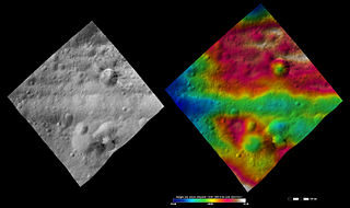
Original caption: Apparent brightness and topography images of Divalia Fossa and Rubria and Occia craters The left-hand image is a Dawn FC (framing camera) image, which shows the apparent brightness of Vesta’s surface. The right-hand image is based on this apparent brightness image, which has had a color-coded height representation of the topography overlain onto it. The topography is calculated from a set of images that were observed from different viewing directions, which allows stereo reconstruction. The various colors correspond to the height of the area. The white and red areas in the topography image are the highest areas and the blue areas are the lowest areas. These images show a part of the large trough, Divalia Fossa, which encircles most of Vesta’s equator. Divalia Fossa is visible in both the apparent brightness image and the topography image: it is the approximately 10 kilometer (6 mile) wide depression that runs from the left corner to the right corner of the images. The top rim of Divalia Fossa is especially clear in the topography image. A number of smaller troughs above and below Divalia Fossa are parallel to it. Rubria and Occia craters straddle Divalia Fossa: Rubria is the crater with dark and bright material above Divalia Fossa and Occia is the crater with bright and dark material below. These images are located in Vesta’s Gegania quadrangle, just south of Vesta’s equator. NASA’s Dawn spacecraft obtained the apparent brightness image with its framing camera on Oct. 16, 2011. This image was taken through the camera’s clear filter. The distance to the surface of Vesta is 700 kilometers (435 miles) and the image has a resolution of about 70 meters (230 feet) per pixel. This image was acquired during the HAMO (high-altitude mapping orbit) phase of the mission. These images are lambert-azimuthalmap projected. |
| Date | |
| Source | http://dawn.jpl.nasa.gov/multimedia/imageoftheday/image.asp?date=20120711 |
| Author | NASA/ JPL |
Licensing
| This file is in the public domain in the United States because it was solely created by NASA. NASA copyright policy states that "NASA material is not protected by copyright unless noted". (See Template:PD-USGov, NASA copyright policy page or JPL Image Use Policy.) | ||
 |
Warnings:
|
Original upload log
| Date/Time | Dimensions | User | Comment |
|---|---|---|---|
| 2012-09-15 09:46 | 2700×1600× (756667 bytes) | Kwamikagami | Uploading a public-domain item using [[Wikipedia:File_Upload_Wizard|File Upload Wizard]] |

|
The categories of this image need checking. You can do so here.
|
File history
Click on a date/time to view the file as it appeared at that time.
| Date/Time | Thumbnail | Dimensions | User | Comment | |
|---|---|---|---|---|---|
| current | 11:02, 25 November 2015 | | 2,700 × 1,600 (739 KB) | PlanetUser | Transferred from en.wikipedia |
File usage
The following 2 pages use this file:
Global file usage
The following other wikis use this file:
- Usage on de.wikipedia.org
- Usage on en.wikipedia.org
- Usage on mk.wikipedia.org
- Usage on ro.wikipedia.org
- Usage on ru.wikipedia.org
- Usage on uk.wikipedia.org
- Usage on zh.wikipedia.org