File:Cg-map.png
Jump to navigation
Jump to search
No higher resolution available.
Cg-map.png (326 × 350 pixels, file size: 19 KB, MIME type: image/png)
| This is a file from the Wikimedia Commons. The description on its description page there is shown below.
Commons is a freely licensed media file repository. You can help. |
Summary
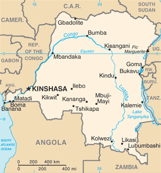
| Description | Democratic Republic of the Congo map from CIA World Factbook, converted from original GIF format (July 2011 version showing South Sudan) |
| Date | |
| Source |
CIA World Factbook |
| Author | United States Central Intelligence Agency |
| Other versions |
|
Licensing
This image is in the public domain because it contains materials that originally came from the United States Central Intelligence Agency's World Factbook.
|
 |
Derivative works
Derivatives of 2011 map (showing South Sudan):
-
 Congo CIA map PL.png
polski

Derivatives of 2002 map:
-
 Congo Rep Dem carte.gif
français -
 DRK kaart.png
Afrikaans -
 Karte der Demokratischen Republik Kongo.png
Deutsch -
 Mapa dem rep Kongo.png
čeština


File history
Click on a date/time to view the file as it appeared at that time.
| Date/Time | Thumbnail | Dimensions | User | Comment | |
|---|---|---|---|---|---|
| current | 10:22, 17 January 2022 | | 326 × 350 (19 KB) | Lojwe | Cropped 1 % horizontally, 1 % vertically using CropTool with precise mode. |
| 08:28, 14 September 2016 |  | 330 × 354 (55 KB) | Yerpo | Reverted to version as of 00:12, 13 July 2011 (UTC) | |
| 00:00, 14 September 2016 |  | 354 × 330 (20 KB) | SteinsplitterBot | Bot: Image rotated by 90° | |
| 00:12, 13 July 2011 |  | 330 × 354 (55 KB) | Béka~commonswiki | new version with South Sudan, from CIA | |
| 22:53, 4 March 2005 |  | 330 × 355 (14 KB) | Alfio | CIA map of Congo Democratic Republic |
File usage
The following 3 pages use this file:
Global file usage
The following other wikis use this file:
- Usage on ab.wikipedia.org
- Usage on ar.wikipedia.org
- Usage on azb.wikipedia.org
- Usage on be-tarask.wikipedia.org
- Usage on be.wikipedia.org
- Usage on bn.wikipedia.org
- Usage on ca.wikipedia.org
- Usage on cy.wikipedia.org
- Usage on da.wikipedia.org
- Usage on de.wiktionary.org
- Usage on en.wikipedia.org
- Democratic Republic of the Congo
- Oral polio vaccine AIDS hypothesis
- Portal:Democratic Republic of the Congo
- Index of Democratic Republic of the Congo–related articles
- Wikipedia:WikiProject Democratic Republic of the Congo
- User:SmithBlue/AIDSOPVuniverse
- 2008 Congo football riots
- Sexual violence in the Democratic Republic of the Congo
- User:Francish7
- Template:User WikiProject Democratic Republic of the Congo
- Category:WikiProject Democratic Republic of the Congo participants
- User:NhInsideWriter
- Module:Location map/data/Democratic Republic of the Congo/doc
- Wikipedia:Userboxes/WikiProjects/Regional/03
- User:Crtew/Serge Maheshe
- Wikipedia:Userboxes/WikiProjects/alphabetical/08
- Wikipedia:Userboxes/WikiProjects/alphabetical/09
- Module:Location map/data/Democratic Republic of the Congo
- Wikipedia:Userboxes/Location/Democratic Republic of the Congo
- The Democratic Republic of the Congo and the World Bank
- User:Unbeatable101/sandbox/DRoC
- User:Northamerica1000/Portals of the world
- Usage on en.wikinews.org
- Usage on eo.wikipedia.org
View more global usage of this file.