File:Baylonianmaps.JPG

Original file (1,728 × 2,349 pixels, file size: 870 KB, MIME type: image/jpeg)
| This is a file from the Wikimedia Commons. The description on its description page there is shown below.
Commons is a freely licensed media file repository. You can help. |
Summary
| Description |
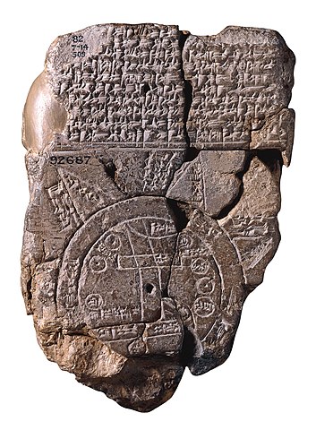
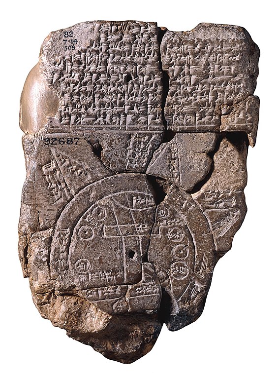
English: Map showing Assyria, Babylonia and Armenia.
Français : Carte montrant l'Assyrie, la Babylonie et l'Arménie.
العربية: "خَريطة العالم البَابِلي" |
| Source | British Museum. Object Number: 92687. |
| Author | |
| Permission (Reusing this file) |
bu j. CNN h hmm vcم ذ،0650:::؛ دذد ذپدرانهدرتدتغداتعنذپدپ از در زمان راد لوری در راذ تا از زیر با نام اصلی درد دذد ذپدرانهدرتدتغداتعنذپدپ از اولین افرادی بودند که دروازه های دنیا دلتان درک بهتر موضوع دارند |
,,();!!!;-;!:; n,hcv,::';::6: cegb,:!:!&_-66--+:++:(
Licensing
|
This work is in the public domain in its country of origin and other countries and areas where the copyright term is the author's life plus 70 years or fewer.
| |
| This file has been identified as being free of known restrictions under copyright law, including all related and neighboring rights. | |
File history
Click on a date/time to view the file as it appeared at that time.
| Date/Time | Thumbnail | Dimensions | User | Comment | |
|---|---|---|---|---|---|
| current | 13:43, 2 July 2020 | | 1,728 × 2,349 (870 KB) | Sette-quattro | higher quality |
| 21:00, 5 March 2007 |  | 368 × 500 (187 KB) | Artaxiad | Courtesy of the British Museum. Map showing Assyria, Babylonia and Armenia. |
File usage
The following 2 pages use this file:
Global file usage
The following other wikis use this file:
- Usage on ar.wikipedia.org
- Usage on azb.wikipedia.org
- Usage on az.wikipedia.org
- Usage on bg.wikipedia.org
- Usage on bn.wikipedia.org
- Usage on bs.wikipedia.org
- Usage on ca.wikipedia.org
- Usage on ckb.wikipedia.org
- Usage on de.wikipedia.org
- Usage on el.wikipedia.org
- Usage on en.wikipedia.org
- Usage on eo.wikipedia.org
- Usage on es.wikipedia.org
- Usage on eu.wikipedia.org
- Usage on fa.wikipedia.org
- Usage on fa.wikibooks.org
- Usage on fi.wikipedia.org
- Usage on fr.wikipedia.org
View more global usage of this file.