File:Antarctic shelf ice hg.png
Jump to navigation
Jump to search

Size of this preview: 800 × 494 pixels. Other resolutions: 320 × 197 pixels | 640 × 395 pixels | 1,024 × 632 pixels | 1,280 × 790 pixels | 2,834 × 1,749 pixels.
Original file (2,834 × 1,749 pixels, file size: 196 KB, MIME type: image/png)
| This is a file from the Wikimedia Commons. The description on its description page there is shown below.
Commons is a freely licensed media file repository. You can help. |

|
This geology image could be re-created using vector graphics as an SVG file. This has several advantages; see Commons:Media for cleanup for more information. If an SVG form of this image is available, please upload it and afterwards replace this template with
{{vector version available|new image name}}.
It is recommended to name the SVG file “Antarctic shelf ice hg.svg”—then the template Vector version available (or Vva) does not need the new image name parameter. |
SVG version : File:Antarctic_shelf_ice_fr.svg
Summary
| Description |
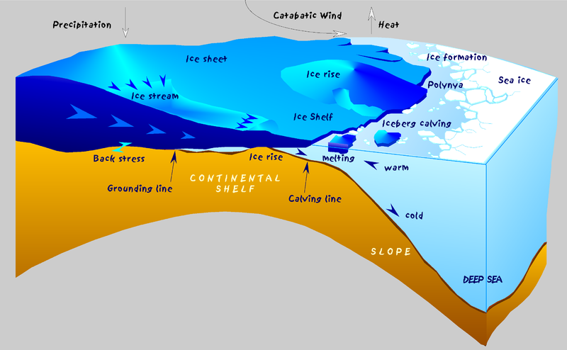
English: Sketch of the Antarctic coast with glaciological and oceanographic processes.
Deutsch: Schematische Darstellung glaziologischer und ozeanographischer Prozesse an der Küste der Antarktis. Über dem antarktischen Eisschild fällt Niederschlag in Form von Schnee (Precipitation). Der Eisschild (Ice sheet) ist weitgehend am Untergrund festgefroren (back stress) und hat sich bis zu einer Mächtigkeit von über 4000 m aufgebaut. Das Eis fließt nach allen Seiten vom Kontinent ab, z.T. konzentriert in Eisströmen (Ice stream). An der Küste verliert das Eis im Bereich der Aufsetzlinie (Grounding line) den Kontakt zum Untergrund, wird deutlich dünner (einige 100 m) und bildet über dem Schelf (Continental shelf) ein Schelfeis (Ice shelf) = Eis, das noch mit dem Eisschild verbunden ist, aber bereits schwimmt. Fließt das Schelfeis über eine Untiefe, entstehen Eisrücken (Ice rise). An der Schelfeiskante brechen Tafeleisberge ab (Calving line, Iceberg calving), die auf ihrem Weg um die Antarktis in wärmerem Wasser schmelzen. Eine Küstenpolynya entsteht, wenn kalte ablandige Winde (Catabatic wind) das Meereis (Sea ice) von der Küste wegtreiben. In Verbindung mit der Neueisbildung entsteht kaltes, salzreiches und damit schweres Wasser, das den Kontinentalhang (Slope) herabfließt und den wesentlichen Mechanismus für die Bildung des ozeanischen Bodenwassers in der Tiefsee (Deep sea) darstellt. |
| Date | |
| Source | Own work |
| Author | Hannes Grobe, Alfred Wegener Institute for Polar and Marine Research, Bremerhaven, Germany |
| Permission (Reusing this file) |
Own work, share alike, attribution required (Creative Commons CC-BY-SA-2.5) |
Licensing
I, the copyright holder of this work, hereby publish it under the following license:
This file is licensed under the Creative Commons Attribution-Share Alike 2.5 Generic license.
- You are free:
- to share – to copy, distribute and transmit the work
- to remix – to adapt the work
- Under the following conditions:
- attribution – You must give appropriate credit, provide a link to the license, and indicate if changes were made. You may do so in any reasonable manner, but not in any way that suggests the licensor endorses you or your use.
- share alike – If you remix, transform, or build upon the material, you must distribute your contributions under the same or compatible license as the original.
File history
Click on a date/time to view the file as it appeared at that time.
| Date/Time | Thumbnail | Dimensions | User | Comment | |
|---|---|---|---|---|---|
| current | 22:56, 6 October 2016 | | 2,834 × 1,749 (196 KB) | Cmdrjameson | Compressed with pngout. Reduced by 117kB (37% decrease). |
| 23:05, 21 July 2006 |  | 2,834 × 1,749 (314 KB) | Hgrobe | {{Information| |Description= |Source=own work |Date=2000-04-07 |Author=~~~~ |Permission=Own work, share alike, attribution required (Creative Commons CC-BY-SA-2.5) |other_versions= }} {{self|cc-by-sa-2.5}} Category:Ice, Antarctica |
File usage
The following 4 pages use this file:
Global file usage
The following other wikis use this file:
- Usage on als.wikipedia.org
- Usage on ar.wikipedia.org
- Usage on ast.wikipedia.org
- Usage on beta.wikiversity.org
- Usage on ca.wikipedia.org
- Usage on cs.wikipedia.org
- Usage on da.wikipedia.org
- Usage on da.wikibooks.org
- Usage on de.wikipedia.org
- Usage on el.wikipedia.org
- Usage on en.wikipedia.org
- Usage on eo.wikipedia.org
- Usage on es.wikipedia.org
- Usage on eu.wikipedia.org
- Usage on fa.wikipedia.org
- Usage on fi.wikipedia.org
- Usage on fr.wikipedia.org
- Usage on gl.wikipedia.org
- Usage on he.wikipedia.org
- Usage on hi.wikipedia.org
- Usage on hu.wikipedia.org
- Usage on ig.wikipedia.org
- Usage on is.wikipedia.org
- Usage on it.wikipedia.org
- Usage on ja.wikipedia.org
View more global usage of this file.