File:Africa slave Regions.svg
Jump to navigation
Jump to search

Size of this PNG preview of this SVG file: 635 × 600 pixels. Other resolutions: 254 × 240 pixels | 508 × 480 pixels | 813 × 768 pixels | 1,084 × 1,024 pixels | 2,169 × 2,048 pixels | 1,525 × 1,440 pixels.
Original file (SVG file, nominally 1,525 × 1,440 pixels, file size: 565 KB)
| This is a file from the Wikimedia Commons. The description on its description page there is shown below.
Commons is a freely licensed media file repository. You can help. |
| Description |
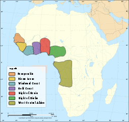
English: Map depicting major slave trading regions of Africa African continent. |
| Date | (UTC) |
| Source |
|
| Author |
|
| This is a retouched picture, which means that it has been digitally altered from its original version. Modifications: Created Map of Slave Trading Regions. The original can be viewed here: Africa map no countries.svg:
|
I, the copyright holder of this work, hereby publish it under the following licenses:
This file is licensed under the Creative Commons Attribution-Share Alike 2.5 Generic, 2.0 Generic and 1.0 Generic license.
- You are free:
- to share – to copy, distribute and transmit the work
- to remix – to adapt the work
- Under the following conditions:
- attribution – You must give appropriate credit, provide a link to the license, and indicate if changes were made. You may do so in any reasonable manner, but not in any way that suggests the licensor endorses you or your use.
- share alike – If you remix, transform, or build upon the material, you must distribute your contributions under the same or compatible license as the original.
| This file is licensed under the Creative Commons Attribution-Share Alike 3.0 Unported license. | ||
| ||
| This licensing tag was added to this file as part of the GFDL licensing update. |

|
Permission is granted to copy, distribute and/or modify this document under the terms of the GNU Free Documentation License, Version 1.2 or any later version published by the Free Software Foundation; with no Invariant Sections, no Front-Cover Texts, and no Back-Cover Texts. A copy of the license is included in the section entitled GNU Free Documentation License. |
You may select the license of your choice.
Original upload log
This image is a derivative work of the following images:
- File:Africa_map_no_countries.svg licensed with Cc-by-sa-2.5,2.0,1.0, Cc-by-sa-3.0-migrated, GFDL
- 2010-03-10T18:28:40Z Zscout370 1525x1440 (510768 Bytes) {{Information |Description={{en|Blank map of the [[:Category:Maps of Africa|African continent]].}} {{fr|Carte vierge du [[:Category:Maps of Africa|continent africain]].}} Lambert azimutal equal-area projection, WGS84 datum, s
Uploaded with derivativeFX
File history
Click on a date/time to view the file as it appeared at that time.
| Date/Time | Thumbnail | Dimensions | User | Comment | |
|---|---|---|---|---|---|
| current | 03:13, 27 March 2011 | | 1,525 × 1,440 (565 KB) | Grin20 | Continued text rendering errors~~~~ |
| 03:04, 27 March 2011 |  | 1,525 × 1,440 (565 KB) | Grin20 | Text Reformatting ~~~~ | |
| 15:54, 20 March 2011 |  | 1,525 × 1,440 (566 KB) | Grin20 | More text fixes | |
| 15:45, 20 March 2011 |  | 1,525 × 1,440 (567 KB) | Grin20 | Text Box fixes | |
| 15:38, 20 March 2011 |  | 1,525 × 1,440 (568 KB) | Grin20 | Fixed Text Boxes | |
| 15:35, 20 March 2011 |  | 1,525 × 1,440 (569 KB) | Grin20 | {{Information |Description={{en|Map depicting major slave trading regions of Africa African continent.}} |Source=*File:Africa_map_no_countries.svg * Inspired by {{cite book |last= Benjamin |first= Thomas |title= The Atl |
File usage
The following page uses this file:
Global file usage
The following other wikis use this file:
- Usage on af.wikipedia.org
- Usage on ast.wikipedia.org
- Usage on ca.wikipedia.org
- Usage on cs.wikipedia.org
- Usage on en.wikipedia.org
- Usage on fr.wikipedia.org
- Usage on ha.wikipedia.org
- Usage on hy.wikipedia.org
- Usage on it.wikipedia.org
- Usage on ja.wikipedia.org
- Usage on ka.wikipedia.org
- Usage on om.wikipedia.org
- Usage on pl.wikipedia.org
- Usage on pt.wikipedia.org
- Usage on ro.wikipedia.org
- Usage on ru.wikipedia.org
- Usage on sd.wikipedia.org
- Usage on tum.wikipedia.org
- Usage on uk.wikipedia.org
- Usage on yo.wikipedia.org
- Usage on zh.wikipedia.org
- Usage on zh.wikibooks.org