File:Earth apollo17.jpg

From Wikiversity
Jump to navigation Jump to search

Earth_apollo17.jpg(512 × 507 pixels, file size: 45 KB, MIME type: image/jpeg)

This is a file from the Wikimedia Commons. The description on its description page there is shown below.

Commons is a freely licensed media file repository. You can help.

Summary

Description
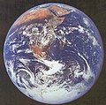
English: A view of Southern Emisphere taken 21 750 nautical miles (40 281 kilometres) from Earth that shows the coasts of Africa. This image is in the public domain from NASA (#AS17-148-22727). It was taken by US Navy Captain Ronald E. Evans aboard Apollo 17 mission, on 7 December 1972. He used a 70mm Hasselblad camera. See also NASA's page on this photo, including confirmation that it is not protected by copyright. NASA notes: "View of the Earth as seen by the Apollo 17 crew traveling toward the Moon. This translunar coast photograph extends from the Mediterranean Sea area to the Antarctica South polar ice cap. This is the first time the Apollo trajectory made it possible to photograph the South polar ice cap. Note the heavy cloud cover in the Southern Hemisphere. Almost the entire coastline of Africa is clearly visible. The Arabian Peninsula can be seen at the Northeastern edge of Africa. The large island off the coast of Africa is the Malagasy Republic. The Asian mainland is on the horizon toward the Northeast."
Italiano: Una veduta dell'emisfero meridionale da 21 750 miglia nautiche (40 281 chilometri) dalla Terra, raffigurante le coste dell'Africa. L'immagine è stata rilasciata in pubblico dominio dalla NASA (numero AS17-148-22727). La fotografia fu scattata il 7 dicembre 1972 dall'Apollo 17 dal capitano di Marina Ronald E. Evans, che usò una macchina fotografica Hasselblad 70mm. La didascalia della NASA recita: «Vista della Terra dall'Apollo 17 in viaggio verso la Luna. L'immagine va dal Mediterraneo fino alla calotta antartica; fu la prima volta che la traiettoria dell'Apollo rese possibile fotografare la calotta polare. Si noti l'intensa nuvolosità dell'emisfero meridionale; quasi tutta la costa africana è visibile. La penisola arabica è visibile al margine nordorientale dell'Africa. La vasta isola di fronte alle coste africane è il Madagascar. Il continente asiatico si trova sull'orizzonte a nordest»
Date
Source GRIN, Great Images in NASA, GRIN Databasa Number GPN-2000-001138
Author NASA/GSFC
Permission
(Reusing this file)
Public domain This file is in the public domain in the United States because it was solely created by NASA. NASA copyright policy states that "NASA material is not protected by copyright unless noted". (See Template:PD-USGov, NASA copyright policy page or JPL Image Use Policy.)
Warnings:

Captions

Add a one-line explanation of what this file represents

Items portrayed in this file

depicts

7 December 1972

File history

Click on a date/time to view the file as it appeared at that time.

Date/TimeThumbnailDimensionsUserComment
current04:22, 20 March 2006Thumbnail for version as of 04:22, 20 March 2006512 × 507 (45 KB)DaleMThis image is in the public domain, from NASA, image #AS17-148-22727. Taken by US Navy Captain Ronald E. Evans, aboard Apollo 17 mission, on 7 December 1972. He used a 70mm Hasselblad camera. This view of Earth was taken 21 750 nautical miles from Earth

The following page uses this file:

Global file usage

Metadata